Storm Country
In August 2024, a hailstorm drove the second-costliest insured disaster in Canadian history. In 2020, another storm caused over a billion dollars in damage while the city was already locked down. In 2013, 80,000 people evacuated as the Bow and Elbow Rivers turned Calgary into an inland sea. These are not coincidences. They are consequences of geography — and a climate system being pushed past thresholds it once only rarely reached.
Prologue: The Second-Costliest Insured Disaster in Canadian History
On August 5, 2024, a convective storm cell built above the Rocky Mountain foothills west of Calgary in the way Alberta storms have always built — rapidly, with almost no warning, in the late afternoon heat. By the time it crossed the city, it had grown into something that would take months to fully account for. Golf-ball-sized hail stripped paint from vehicles, punched through skylights, and collapsed canopies across thousands of properties from the northwest quadrants to the southeast. The Insurance Bureau of Canada would eventually tally the insured losses at approximately $2.8 billion — surpassed in Canadian history only by the Fort McMurray wildfire a decade earlier.
The August 2024 storm was not an aberration. It was the latest entry in a ledger that has been accumulating for two decades, and accelerating for one. To understand why, you have to understand where Calgary is.
Part A: At the Edge of Everything
Calgary occupies one of the most meteorologically contested positions on the North American continent. It sits at 51°N, 114°W, at an elevation of roughly 1,050 metres above sea level — high enough to be clipped by weather systems that pass beneath most Prairie cities, low enough that the Rockies to its immediate west force those systems to do something dramatic as they arrive.
Scroll through the geographic context below.
Alberta in context. The province occupies the western edge of the Interior Plains — a vast, flat-to-rolling landscape that extends without significant topographic interruption from the Gulf of Mexico to the Arctic Ocean. Cold air generated over the high Arctic has a nearly unobstructed 3,000-kilometre corridor south to Calgary and back again. Purple dashed line: the principal Arctic air mass corridor into Alberta. Calgary is the most significant city sitting near the southern entrance of that corridor, and its elevation of 1,050 m — higher than any other major Prairie city — means it receives the full force of these incursions.
The Rocky Mountain wall. Immediately west of Calgary, the Front Ranges rise to 3,000 metres and above — a near-vertical wall relative to the Prairie surface. Grey line: the foothills transition zone where the Rockies meet the plains. The wall blocks Pacific moisture, producing southern Alberta's semi-arid character. But it also acts as a launch ramp: air masses that crest the Rockies and descend rapidly on the eastern side warm adiabatically at 10°C per 1,000 m of descent — producing the Chinook wind that can lift Calgary's temperature by 20°C in an afternoon.
The confluence position. Calgary sits at the junction of two major river drainages. Blue: the Bow River watershed (~25,000 km²), draining from the Columbia Icefield south of Banff. Cyan: the Elbow River watershed (~1,200 km²), draining the Kananaskis highlands. Both rivers exit the mountains and converge in Calgary's inner core. The city's river valleys cut 60–90 m below the surrounding plateau — a funnel that concentrates floodwaters into the urban fabric in ways that flat-lying cities do not experience. When both watersheds produce coincident flood pulses, there is nowhere for the water to go but through.
Hail alley. In summer, warm moist air from the Gulf of Mexico flows northward along the eastern Rockies slope, colliding with drier continental air over the Alberta foothills. Orange: the principal hail belt, where this collision drives the most intense convective activity in Canada. Supercell thunderstorms grow to exceptional heights in Alberta's atmospheric profile — tall enough for hailstones to cycle up and down in updrafts until they exceed 5 cm. The zone from Calgary south to the U.S. border receives more large-hail events per year than almost anywhere else in the country.
The Arctic corridor. Northern Alberta connects without barrier to the sub-Arctic. Purple dashed line: the corridor through which polar air masses descend. When polar vortex displacements push Arctic air southward, Alberta is among the first populated regions to receive the full force — temperatures below -40°C with windchill, power grid stress, and the pipe-freeze damage that characterised the January 2024 event. What makes Calgary's exposure distinctive is that all four of these systems — Arctic, Rockies, Gulf moisture, and the continental interior — operate simultaneously, interacting in a relatively small geographic envelope. No other major Canadian city sits at this particular intersection.
What Calgary experiences, then, is the intersection of four distinct meteorological forces: Arctic air moving south through an unobstructed continental corridor; Pacific air that has been wrung of most of its moisture by the Rockies but still carries energy; Gulf moisture that travels north in summer along the eastern slope, generating convective instability; and the Chinook mechanism, which periodically overwrites all of the above with a rapid warm, dry descent from the mountains.
No other major Canadian city sits at this particular intersection. Toronto is sheltered by the Great Lakes. Vancouver is dominated by Pacific influence. Edmonton is farther from the foothills and the Gulf moisture plume. Calgary is exposed to all of it, simultaneously, in a climate envelope that is already marginal enough that relatively small changes in the dominant pattern produce dramatically different outcomes.
Part B: Hail Alley — The Defining Hazard
Of all the weather threats Calgary faces, hail is the most distinctive and, increasingly, the most costly. The city lies at the northern end of what meteorologists and insurers call the “hail belt” — a zone stretching from Texas and Oklahoma north through eastern Colorado, Wyoming, and Montana into southern Alberta where the atmospheric dynamics for supercell development are nearly perfect.
The mechanism is straightforward in outline, complex in execution. Gulf moisture flows north along the eastern slope of the Rockies — the dry line, where moist Gulf air meets drier continental air, is one of the most productive boundaries for severe convection in North America. When that boundary passes through Alberta in late spring and summer, it triggers thunderstorms capable of producing hail because Alberta’s atmospheric profile allows storm towers to grow exceptionally tall. Tall towers mean hailstones have longer to grow, cycling up and down in updrafts before they eventually fall. Hailstones of 5 cm — roughly golf-ball size — are not uncommon in major Calgary events. The August 2024 storm produced stones larger than 7 cm in some locations.
The cost trend above is not primarily a story about storms getting worse — though that is part of it. It is also a story about exposure growth. Calgary’s population grew from roughly 900,000 in 2010 to over 1.4 million by 2024. The footprint of insurable property — homes, vehicles, commercial roofing — expanded dramatically in the northeast and southeast quadrants of the city that happen to lie directly in the most frequent hail tracks. A storm that in 2005 would have rolled over suburban fringe and agricultural land now rolls over dense residential development with replacement values many times higher.
The Pandemic Storm — June 2020
In the spring of 2020, with the city under COVID-19 restrictions and automobile traffic down to a fraction of its normal level, a severe convective system crossed Calgary in the early evening of June 13th. The pandemic context meant that assessment of the damage took longer than usual — adjusters couldn’t simply enter homes — but the eventual accounting was stark: approximately $1.2 billion in insured losses, placing the event among the costliest single-day weather events in Canadian history at the time.
The irony of the pandemic storm was its visibility. With streets empty and Calgarians watching from windows, the storm had an unusual number of witnesses. Videos circulated of marble-sized hail accumulating ankle-deep in minutes, of vehicles pocked and windshields shattered across thousands of properties, of residential streets running with white streams of melted hailstones long after the storm had passed. Insurance industry veterans later described the June 2020 event as a turning point in how Alberta insurers modelled extreme hail risk — the kind of event that had previously anchored the far tail of the probability distribution had now happened twice in a decade, and the tail was thickening.
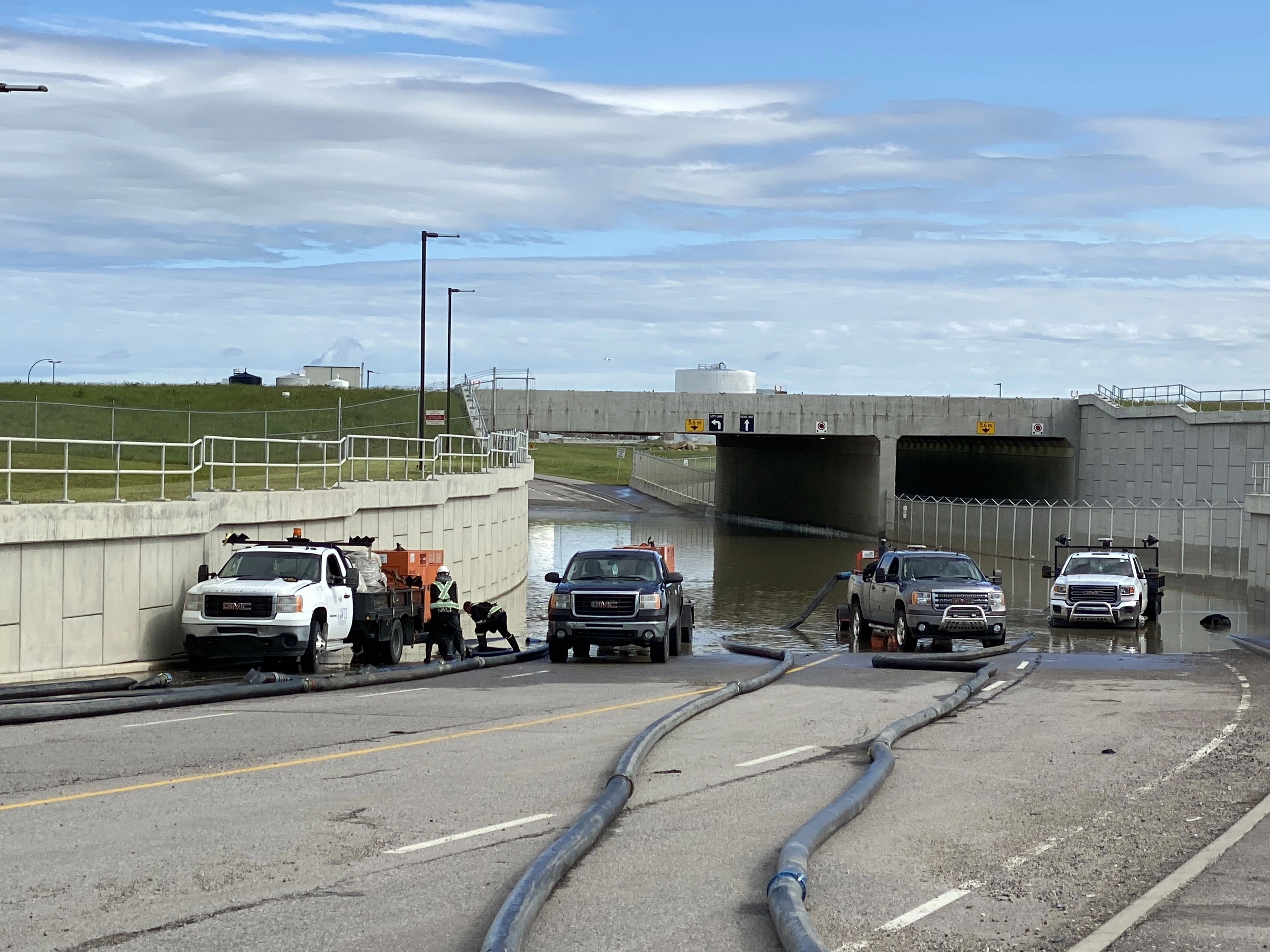
August 2024 — The Record
Four years later, Calgary’s record was shattered in a single August afternoon.
The August 5, 2024 storm tracked northwest to southeast across the city, crossing some of Calgary’s densest residential neighbourhoods. Damage reports flooded in from communities across the northwest and northeast quadrants. The Insurance Bureau of Canada confirmed it as the second-costliest insured weather event in Canadian history — behind only the 2016 Fort McMurray wildfire’s $3.7 billion in losses. The $2.8 billion tally covered an estimated 70,000+ property claims and well over 100,000 vehicle claims.
More significant than the dollar amount was what the 2024 storm revealed about insurance market dynamics in Alberta. Following the 2020 event, many insurers had quietly tightened hail coverage terms, raised deductibles, and begun tiering premiums by geographic risk zone within Calgary. After 2024, the restructuring accelerated. Sewer backup coverage, roof endorsements, and comprehensive automobile coverage all came under pressure. For the first time, actuaries began discussing whether parts of Calgary’s northwest were approaching a level of hail risk that private insurance markets would struggle to price without government backstop programs.
July 2025 — Tornadoes Enter the Frame
The most recent entry in Calgary’s extreme weather ledger arrived in July 2025, when a severe storm brought not only large hail and intense rainfall but also confirmed an F0 tornado — a brief but genuine tornado touchdown within Calgary’s urban boundary. While F0 tornadoes are not structurally catastrophic, their occurrence signals convective intensity: the storm system was energetic enough to produce rotation. Insurance losses from the July 2025 event remained preliminary at time of writing, but early estimates ranged well into the hundreds of millions.
Part C: When the Rivers Swallowed the City — June 2013
If hailstorms are Calgary’s chronic hazard — frequent, costly, but recoverable — the 2013 flood was its acute catastrophe. Nothing in the city’s modern history matched it for scale of disruption. And unlike a hailstorm, which is a two-hour event followed by a long recovery, the 2013 flood was a process — one that unfolded across days and in stages, each stage amplifying the next. Understanding why it happened requires following the water from where it began, high in the Rocky Mountains, to where it ended up.
Stage 1: An Exceptional Snowpack
Alberta’s mountain watersheds accumulate snowpack through winter and release it through spring and early summer. Most years this process is gradual — snowmelt feeds the rivers at a rate the drainage system can absorb. The winter of 2012–13 was not most years. Above-normal snowfall combined with a cold April and May meant that by early June 2013, the Bow and Elbow watersheds were carrying roughly 150–200% of their normal snowpack for the date. The rivers were already running high before the storm arrived.
This is the starting condition that hydrological models capture. In the snowmelt process framework (Series 2, Model 21 — Snowmelt Processes), the energy balance equation for the snowpack determines melt rate from radiation, sensible heat, and rainfall inputs. In June 2013, the snowpack had not fully melted because temperatures had been consistently below the threshold for fast melt. The mountain watershed was, in effect, a charged reservoir — enormous stored water waiting for a trigger.
Stage 2: The Storm System
On June 19th, a strong upper-level ridge over the northeastern Pacific sent a low-pressure trough digging southward across the Yukon and into the Rocky Mountains. This is a recognisable Alberta weather pattern but an extreme expression of it — the trough was slow-moving, deep, and drawing an anomalously moist air mass northward from the Gulf of Mexico along the eastern Rockies slope.
The result was continuous heavy precipitation over the upper Bow and Elbow watersheds for approximately 36–48 hours beginning late on June 19th. Environment and Climate Change Canada recorded rainfall totals at some mountain stations equivalent to 180–200% of the normal June monthly total in a single event. This was rain falling on already-saturated soil — onto a snowpack primed by a cold spring, at altitudes where infiltration into near-frozen ground is minimal.
The hydrological consequence was almost total conversion of rainfall to runoff. Where normally perhaps 30–40% of rainfall in forested mountain terrain runs off directly (the remainder absorbed by soil, intercepted by vegetation, or percolating to groundwater), the saturated and frozen conditions during June 2013 pushed effective runoff ratios close to 80–90%. The physics are captured in the infiltration-excess and saturation-excess runoff frameworks (Series 2, Model 18 — Runoff Generation Mechanisms): when the soil water deficit is near zero, virtually all rainfall becomes surface flow.
Stage 3: Two Watersheds, Two Pulses — and a Fatal Coincidence
The Bow and Elbow rivers respond differently to storm events because of their watershed geometries. The Bow watershed is large (~25,000 km²) and elongated east-west. Its travel time — the interval from headwaters precipitation to the Calgary gauge — is on the order of 12–24 hours for major events. The Elbow watershed is smaller (~1,200 km²) and more compact; its travel time is shorter.
In a typical storm, these different response times create a natural offset: the Elbow peaks before the Bow, and the Bow’s peak arrives as the Elbow is receding. This desynchronisation is protective — it means the combined flow through Calgary is rarely the sum of both rivers’ maximums.
June 2013 was an exception. The storm was large enough and long-lasting enough to saturate both watersheds essentially simultaneously. Both rivers entered their rising limb at roughly the same time, peaked within hours of each other, and produced a combined flood pulse that overwhelmed every piece of infrastructure designed on the assumption they would not coincide. The streamflow routing equations (Series 2, Model 20 — Streamflow Routing) describe how a flood wave travels downstream, attenuating as it spreads. At the Elbow-Bow confluence, the waves from both rivers arrived almost together — compressing what would have been sequential crests into a single catastrophic pulse.
Stage 1 — Snowpack (winter 2012–13). By early June, the upper Rocky Mountain catchments were holding 150–200% of their normal snowpack. Pale blue: the principal mountain snowpack accumulation zone feeding the Bow and Elbow systems. A cold April and May had suppressed melt; the watershed functioned as a charged reservoir. The Bow River was already running above its seasonal norm before the first raindrop of the event fell. In the snowmelt process model, the energy balance for the snowpack had not yet been satisfied — there was far more stored water than normal for the date.
Stage 2 — Storm system meets two watersheds. A slow-moving low-pressure trough parked over the Rockies June 19–21, drawing Gulf moisture northward and depositing 180–200% of normal June rainfall in 36–48 hours. Blue: Bow watershed (~25,000 km²). Cyan: Elbow watershed (~1,200 km²). Rain fell on already-saturated, partially-frozen soil. Effective runoff ratios reached 80–90% across both watersheds — virtually every millimetre of rainfall became immediate streamflow. In normal soil conditions, 30–40% of rainfall infiltrates; here, almost none did.
Stage 3 — The fatal coincidence. Under normal conditions, the Elbow River peaks before the Bow — different watershed sizes create an offset that desynchronises their flood pulses and limits combined flow through Calgary. The June 2013 storm was large and persistent enough to saturate both watersheds simultaneously. Both rivers entered their rising limbs together and crested within hours of each other. The infrastructure — Glenmore Reservoir, the Elbow weir system, downtown berms — was designed for sequential peaks, not a coincident double pulse. The combined flow at the confluence exceeded every design threshold.
Stage 4 — The flood pulse (June 21, 2013). Both rivers crested simultaneously. The Bow registered flows roughly ten times its late-June norm. The Elbow overwhelmed Glenmore Reservoir and the weir system protecting downtown. Dark blue: approximate Bow River valley flood corridor. Navy: Elbow River valley flood zone. Water surged into Sunnyside, Bowness, Elbow Park, the Stampede grounds, and the downtown core. The Saddledome's lower bowl flooded to the fourth row of seats. 80,000 residents received evacuation orders — the largest peacetime evacuation in Alberta's history.
Stage 5 — Infrastructure response. The post-2013 programme targeted the most dangerous chokepoint: the Elbow River's ability to overwhelm the city without warning. The McLean Creek dry dam (green marker, SW of the city) detains Elbow flood pulses upstream, releasing water at a controlled rate. Combined with the Sunnyside berm, Elbow valley berm, and an East Village underground storage tunnel, the system is engineered to protect against a repeat 2013-scale event. For the quantitative framework behind these interventions — IDF curves, Log-Pearson flood frequency, and urban detention design — see Series 6, Models 68–70: Flood Hydrology.
Stage 4: The Toll
Approximately 80,000 people were ordered to evacuate — the largest peacetime evacuation in Alberta’s history. The State of Local Emergency lasted weeks. Total economic damage was estimated above $6 billion; insured losses were approximately $1.7 billion. Seventeen Albertans died in flood-related incidents across the province. High River, a smaller city 60 km south, suffered proportionally worse: the entire town was inundated, requiring rebuilding at a scale that dwarfed even Calgary’s losses relative to population. The Siksika Nation, Tsuut’ina Nation, and communities along the Highwood River faced additional dimensions of harm including damage to culturally significant lands and infrastructure.
The 2013 flood was, fundamentally, the bill for a century of development decisions made in a river valley. Like most North American cities, Calgary had grown into its floodplain. The downtown core, Inglewood, Elbow Park, Sunnyside, and dozens of other communities occupied land the rivers periodically claimed. The difference between a high-water year and a catastrophic flood year was not dramatic in meteorological terms — it was the difference between a very wet June and an exceptionally wet one, operating on a landscape primed by an abnormal snowpack.
The Infrastructure Response
In the years following 2013, the City of Calgary and the Province of Alberta committed over $600 million to flood mitigation — a figure that grew as projects were scoped and contracted. The centrepiece is the McLean Creek dry dam on the Elbow River: a large earthen embankment with a controlled outlet, designed to detain flood pulses and release water at a rate the downstream system can absorb. Unlike a conventional reservoir, it holds no permanent water — the valley behind it remains a functioning stream environment until a major flood event triggers detention.
Combined with the Sunnyside berm, the Elbow valley berm, and an underground storage tunnel beneath East Village and Simcoe Drive, these interventions are engineered to protect Calgary against a flood equivalent to June 2013. Whether they are sufficient for events that exceed 2013 — in a climate that is pushing frequency and magnitude upward — is a question the models are still working through. The flood frequency analysis framework (Series 6, Model 69 — Flood Frequency Analysis) underlying infrastructure design uses historical flow records to estimate return periods for various magnitudes. When recalibrated against a warming climate baseline rather than historical data, the return period for a 2013-scale event shortens considerably. Estimating by how much is a frontier problem in applied hydrology.
Part D: Arctic Descents — Cold as Infrastructure Stress
Calgary’s hail record and its flood history get most of the attention. Cold gets less — partly because it is expected, partly because its consequences are diffuse rather than dramatic. But extreme cold events are Alberta’s most geographically widespread natural hazard, and their economic consequences are substantial.
January 2024
In late January 2024, a polar vortex displacement sent a surge of Arctic air southward through the Alberta corridor. Temperatures in Calgary fell below -30°C for multiple consecutive days; with windchill, effective temperatures reached -45°C in some locations. Power demand surged across the province, stressing the Alberta Interconnected Electric System (AIES) and triggering conservation alerts. For several hours on the peak cold day, Alberta came measurably close to rolling blackouts — a scenario grid operators had modelled but never expected to execute.
The sustained cold produced extensive pipe-freeze damage across residential and commercial properties. Insurance industry estimates placed losses from freeze-related damage across Western Canada at approximately $180 million, concentrated in Alberta and British Columbia’s interior. The majority of claims involved burst pipes in homes where heating systems failed during the sustained cold, or in older buildings with inadequate insulation in wall cavities.
The economic damage from the January 2024 event is less dramatic than the hailstorm losses but illuminates a different vulnerability. Hail affects roofs and vehicles — assets that are insured and replaced. Frozen pipe events affect infrastructure: water mains, service connections, sprinkler systems in commercial buildings, and the plumbing in tens of thousands of older homes. The recovery time is longer, the interruption more persistent, and the damage particularly acute for renters and lower-income households whose landlords defer maintenance.
The Chinook Paradox
Calgary’s relationship with cold is complicated — and occasionally overturned within hours — by the Chinook wind.
A Chinook occurs when Pacific air crosses the Rockies and descends on the eastern side, warming adiabatically at approximately 10°C per 1,000 metres of descent. The result can be a temperature increase of 20°C or more within a matter of hours. In January and February, Calgary can move from -25°C to +10°C before the afternoon is out, driven by a wind that Calgarians have learned to read from the distinctive Chinook arch — a bow-shaped clearing in the cloud layer to the west that announces the warm air’s arrival.
The Chinook is beloved for obvious reasons: it breaks the grip of winter cold, melts snow, and periodically makes Calgary feel like a mild West Coast city in the middle of the Prairies. But it carries hazards of its own. Rapid warming creates ice — snow melt during the warm spell refreezes overnight, coating roads, sidewalks, and stairs in a glaze that produces an annual spike in fall-related emergency room visits. Wind speeds during Chinook events routinely exceed 100 km/h in the foothills and frequently reach 80–90 km/h in the city itself, downing trees, damaging roofs, and creating power outages that can last hours to days. The dramatic thermal cycling also stresses building envelopes: the repeated expansion and contraction of materials as temperatures swing 40°C or more in a single week accelerates wear in ways that Canadian building codes, which assume more gradual seasonal transitions, don’t fully account for.
There is also a subtler hydrological consequence. A Chinook in February can melt most of the snowpack in the river valleys, reducing the spring runoff buffer that the watershed management system depends on — or alternatively, depending on what follows, it can leave a partially-depleted snowpack vulnerable to rapid melt if March arrives cold and then suddenly warms. The interactions between Chinook-driven mid-winter melt and spring flood potential are a known complication in Alberta’s flood modelling.
Part E: Fire Weather — The Province that Burns
The essay so far has described Alberta’s atmosphere as a collision zone — Arctic air, Pacific remnants, Gulf moisture, and the Chinook mechanism interacting in an unusually contested geographic envelope. That same atmosphere is also, in fire season, an ignition engine.
Alberta’s wildfire hazard is not geographically coincident with Calgary’s hailstorm hazard. The city itself is not forested — it sits at the prairie-foothills transition, above the major fuel beds. But the provincial fire record is inseparable from the broader extreme weather narrative because it shares the same atmospheric drivers, dominates the same insured loss charts, and confronts the same question of whether the past is an adequate guide to the future. Of the two largest insured natural disasters in Canadian history, both occurred in Alberta. One was a hailstorm. One was a fire.
Green: Alberta’s principal fire-prone zones — the boreal forest (darker) and the foothills transition belt (lighter). Fort McMurray sits near the boreal forest’s centre; Jasper at the mountain-foothills boundary. Both areas share the Chinook and atmospheric instability dynamics described throughout this essay.
The Beast — Fort McMurray, May 2016
The spring of 2016 arrived in northern Alberta with the conditions that fire weather models recognise as extreme: a winter with below-normal snowpack, an unusually warm and dry April, a standing Lightning Ignition Potential index running at or above the 90th historical percentile, and then — in early May — a southwest wind event that brought Chinook-like conditions hundreds of kilometres north of the Chinook belt proper.
The fire ignited southwest of Fort McMurray on May 1st. By May 3rd, driven by sustained winds of 35–70 km/h with gusts exceeding 100 km/h, low relative humidity (as low as 13%), and temperatures close to 30°C — values that in combination constitute an extraordinarily extreme fire weather day — it had crossed the Horse River and entered the city. The evacuation of all 88,000 Fort McMurray residents was ordered in the afternoon of May 3rd, the largest evacuation in Alberta’s history before 2013 and the largest wildfire evacuation in Canadian history at any point.
The fire, which came to be called The Beast, burned approximately 590,000 hectares before it was contained in August 2016. It destroyed more than 2,400 structures — roughly 10% of Fort McMurray’s built environment. The Insurance Bureau of Canada reported insured losses of $3.72 billion, making it the most expensive insured natural disaster in Canadian history.
What made the Fort McMurray fire a fire weather event rather than simply a large fire was the specificity of its atmospheric conditions. The atmospheric profile on May 3rd represented an unusual convergence of the mechanisms this essay has described: a Chinook-analog wind reaching far into the boreal zone, extreme thermal anomalies from a warm spring, and the convective instability that had already charged the atmosphere with lightning strikes that contributed to ignition across a wide front. The fire behaviour modelling (Series 6, Models 60–62 — Fire Science) for events like Fort McMurray shows that fire spread rate is exponentially sensitive to wind speed and fuel moisture — the conditions of May 3rd placed the event on the far right tail of the probability distribution for fire behaviour in that ecosystem.
The Town That Burned — Jasper, July 2024
Eight years after Fort McMurray, wildfire returned to a different part of Alberta with different but equally devastating results. The town of Jasper — a mountain community of 5,000 permanent residents and a major tourism gateway to Jasper National Park — was struck by fire in late July 2024 under conditions that should, by now, be familiar.
The summer of 2024 had been dry across the Rockies. The same high-pressure ridge that contributed to the August hailstorm in Calgary in early August had, through July, been suppressing precipitation across much of the mountain and foothills region. When two fires — one from the north, one from the southwest — approached Jasper on July 22nd, the fuel conditions were exceptional: dry grass, low relative humidity, and Foehn winds funnelling through the mountain valleys at speeds that drove spot fires hundreds of metres ahead of the main front.
Approximately 30% of the town’s structures were destroyed — roughly 1,100 buildings, including a significant portion of the historic townsite that had been developed in the early twentieth century. All 5,000 residents were evacuated. Insured losses were estimated at approximately $880 million, making the Jasper fire among the most significant urban wildfire disasters in Canadian history. Coming within weeks of the August 2024 Calgary hailstorm, the two events together pushed Alberta’s 2024 insured catastrophe losses above $3.5 billion — the worst single-year total in provincial history.
The Shared Atmospheric Driver
The link between fire weather and the other hazard types described in this essay is not coincidental. It runs through the same atmospheric mechanisms.
Chinook winds — the dominant signature of Alberta’s mountain weather — create low relative humidity and high wind speeds regardless of season. In winter, those conditions produce ice and power outages. In late spring and summer, when vegetation has dried and fuel moisture drops, the identical wind pattern produces extreme fire danger. The Fire Weather Index, the standard operational metric used by fire agencies across Canada, weights relative humidity and wind speed heavily — both of which the Chinook mechanism drives in the wrong direction simultaneously.
Convective instability — the same atmospheric condition that generates Calgary’s supercell hailstorms — also produces lightning. Lightning ignition is responsible for the majority of large wildfires in Alberta by area burned (though human ignition accounts for more individual events). A season that generates intense convective activity over the foothills and boreal fringe is simultaneously producing hail events and lightning-ignited fires.
Drought anomalies — often associated with La Niña years or ridge-dominated circulation patterns — reduce fuel moisture across the boreal and subalpine zones in ways that prime the landscape for extreme fire behaviour when the wind events arrive. Both 2016 and 2024 featured spring and summer precipitation deficits that set up the conditions before the ignitions occurred.
The fire weather models capture this: the Canadian Forest Fire Danger Rating System integrates temperature, humidity, wind, and precipitation into indices that are, at their core, derived from the same atmospheric variables that drive every other hazard discussed here. Fire is not a separate category of Alberta extreme weather. It is the same atmosphere operating on a different fuel type.
Part F: The Frequency Question
The events above are dramatic precisely because they are individually memorable — they have names, dates, and dollar amounts attached. But the more important question is whether they represent a trend in frequency, not just individual catastrophes that are becoming more costly due to development exposure.
Stacked by hazard type. Orange: hail and convective storms. Blue: flooding. Red: wildfire. Grey: cold, wind, and other events. 2016 dominated by the Fort McMurray wildfire ($3.72B); 2024 includes the August hailstorm ($2.8B) and Jasper wildfire (~$0.88B). Figures are approximate IBC-derived estimates.
The chart above tells a story that goes beyond any single event. The orange bars — insured losses from Alberta’s catastrophic weather — are not uniformly increasing year-over-year, but the baseline is rising and the peaks are more extreme. Events that would have been unprecedented in 2005 are becoming decadal occurrences. Events that were unthinkable in 2005 — billion-dollar single-day weather events — have now happened at least twice in five years.
The blue line — the count of nationally catastrophic events — shows a similar pattern. Alberta is contributing an increasing share of Canada’s total catastrophic weather loss, from a long-run average that was already disproportionate to its population size.
Is This a Climate Signal?
The honest answer is: partly, and the attribution is technically complex. The exposure explanation — more insurable property in the storm path — accounts for a significant portion of the increasing dollar losses. Calgary’s population grew by roughly 35% between 2010 and 2024, and the northeast quadrants now contain tens of thousands of dwellings where there were fields two decades ago. Those fields couldn’t file insurance claims.
But exposure growth alone doesn’t explain everything. Environment and Climate Change Canada’s analysis of convective severe weather in the Prairie region shows evidence of both an increase in the frequency of large hail events and a potential northward expansion of the most active part of the hail belt. The atmospheric mechanisms are consistent with theoretical expectations: a warming climate increases atmospheric moisture content (roughly 7% more water vapour per degree Celsius of warming, per the Clausius-Clapeyron relation), which fuels convective intensity. The jet stream — which steers weather systems across North America — is showing patterns that allow systems to slow and intensify over Alberta rather than moving through quickly.
The Arctic cold snap pattern is also shifting. While daily average winter temperatures in Calgary have warmed over recent decades, the frequency of extreme cold intrusions — driven by polar vortex displacement events — has not decreased as uniformly as the averages suggest. What has changed is that these events now stand out more sharply from the surrounding baseline, which means infrastructure designed for more consistently cold winters is increasingly subjected to thermal stress in both directions.
Approximate anomaly values derived from Environment and Climate Change Canada data. Calgary’s warming trend exceeds the Canadian national average, which itself exceeds the global mean — consistent with the pattern of amplified warming at higher latitudes and in continental interiors.
Part G: Tornadoes — Alberta’s Quieter Menace
Tornadoes are not what most people associate with Alberta. The image of tornado country is Oklahoma, Kansas, the open flatlands of the American Great Plains under a green-tinted sky. But Alberta — particularly central Alberta, and to a lesser extent the Calgary foothills zone — has one of the highest tornado frequencies per unit area of any Canadian province.
The vast majority of Alberta tornadoes are weak: F0 or F1 on the Fujita scale, short-lived, affecting agricultural land rather than urban areas. But the dynamics that produce them are the same dynamics that produce Calgary’s severe hailstorms — Gulf moisture, lifting along the foothills dry line, convective towers that rotate when wind shear is sufficient. As that convective environment intensifies, the conditions for weak tornado production also intensify.
The 2016 F0 tornado that touched down near Calgary, and the similar F0 event in July 2025, were brief and caused limited structural damage. But they signal something important: as storm cells over Calgary become more intense, the probability of rotation increases. The 2024 August event, though it did not produce confirmed tornadoes, featured mesocyclonic rotation on radar that gave Environment and Climate Change Canada’s Prairie Storm Centre cause to issue tornado watches for parts of the metro area.
No major tornado has struck Calgary’s urban core in the modern era. The geography of probability suggests one will.
Part H: What the Confluence Means — A Synthesis
Calgary is not simply a city that has bad weather. It is a city built at the intersection of four competing weather systems — Arctic, Pacific, continental Gulf, and Rocky Mountain — in a way that guarantees meteorological volatility. That volatility has always been part of the city’s character: the Chinook that clears a February cold snap in an afternoon, the early summer hailstorm that leaves golf balls of ice on the sidewalk, the spring freshet that fills the Bow River bank-to-bank. Calgarians wear this as a kind of regional identity, a marker of toughness.
What is changing is the amplitude.
The toll is not just financial. Each major event leaves a social residue: the family that couldn’t get back into a flood-damaged home for three months, the small business that closed permanently after the insurance claim took a year to settle, the community that reassembled its identity around a shared disaster. Calgary’s disaster resilience has been impressive — the 2013 flood response, and the voluntary community effort that accompanied it, was a genuine social achievement. But resilience that must be exercised repeatedly has a different character than resilience that remains theoretical.
For urban planners, the implications are practical and pressing. The question of where to build — and how to build — in a city that faces both a rising hail hazard and a sustained flood risk is not academic. Calgary’s northeast, where hail tracks run with uncomfortable regularity, is also where the city’s fastest residential growth has occurred. Infrastructure that was engineered for the climate of 1980 is being stress-tested by the climate of 2024. The gap between those two calibrations is where the losses accumulate.
For the insurance industry, Alberta has become a test case. The province is already the highest-cost jurisdiction per capita for weather-related insured losses in Canada. Several major insurers have signalled that they are revisiting their exposure limits in Alberta’s urban hail belt. If private markets begin to withdraw, the question of who bears the residual risk — and how — becomes political as well as actuarial.
And for Calgarians themselves, the question is whether the city’s habitual relationship with extreme weather — stoic, adaptive, quietly proud — is calibrated for the environment that is already here. The 2013 flood felt like a once-in-a-century event. It has been less than fifteen years, and the city has already absorbed two events larger than anything in the preceding century’s record.
Coda: A Ledger Still Being Written
The August 2024 hailstorm will not be Calgary’s last major hail event. The city’s geography, and the meteorological dynamics that converge above it, guarantee that it will not. The question is what the interval between events looks like — and whether the infrastructure, the insurance market, and the planning frameworks that govern development keep pace with what that interval implies.
In October 2024, the City of Calgary approved updated flood maps incorporating the McLean Creek dry dam’s expected performance — a meaningful step in aligning planning with risk. But updated flood maps don’t address hail risk, which has no equivalent infrastructure solution. Hardening tens of thousands of rooftops is an individual and market challenge, not a public works project.
Alberta’s extreme weather record is, in one reading, a story about a geographically exceptional place that was always going to face exceptional weather. In another reading, it is a story about the consequences of building a major city without fully accounting for what the land it sits on will ask of it. Those two readings are not mutually exclusive. Calgary is both genuinely extraordinary in its meteorological exposure — positioned as it is between the Arctic, the Rockies, and the continental interior — and has made choices, over decades, that turned natural hazard into financial and social catastrophe on a scale that better-prepared choices might have moderated.
The ledger is still being written. The 2025 July storm’s final tally was not in at time of publication. The question of whether the August 2024 record will stand for five years or for five months is genuinely open. What the record shows is that the interval between new entries is shortening.
References and Further Reading
Extreme Weather Events — Primary Sources
Insurance Bureau of Canada. Catastrophic Event Database. Annual insured loss estimates by event type and region. Publicly available summary data via IBC media releases and the annual Facts of the Property and Casualty Insurance Industry in Canada. The $2.8 billion August 2024 event and the $1.2 billion June 2020 event are drawn from IBC public announcements.
Environment and Climate Change Canada. Historical Climate Data. Calgary International Airport weather station (Station ID 3031094). Monthly and daily climate normals, 1981–2010 and 1991–2020 reference periods. Available via climate.weather.gc.ca.
Environment and Climate Change Canada. Canadian Disaster Database. Federal record of significant disaster events. The 2013 Alberta floods are catalogued at approximately $6 billion total economic damage and $1.7 billion insured. Entry number AB-2013-0032 and associated provincial records.
Alberta Emergency Management Agency. 2013 Alberta Floods: After Action Report. Province of Alberta, 2014. Documents the sequence of emergency response, evacuation scope (80,000 persons), and the State of Local Emergency timeline.
City of Calgary. Flood Resilience Program — Progress Reports. City of Calgary Infrastructure Services, 2015–2024. Documents the McLean Creek Dry Dam project, Sunnyside berm, Elbow Valley berm, and East Village storage tunnel. Available via calgary.ca/flood.
Climate and Meteorology
Pomeroy, J.W., Stewart, R.E., and Whitfield, P.H. “The 2013 flood event in the South Saskatchewan and Elk River basins: Causes, assessment and damages.” Canadian Water Resources Journal 41(1–2): 105–117, 2016. The definitive peer-reviewed analysis of the meteorological and hydrological drivers of the June 2013 event. Documents the above-normal snowpack, soil saturation conditions, and the simultaneous Bow-Elbow peak.
Milrad, S.M., Gyakum, J.R., and Atallah, E.H. “A meteorological analysis of the 2013 Alberta Flood: Antecedent large-scale flow pattern and synoptic–dynamic characteristics.” Monthly Weather Review 143(7): 2817–2841, 2015. Describes the quasi-stationary upper-level trough, the anomalous moisture transport, and the orographic forcing over the Bow and Elbow watersheds.
Simonovic, S.P. (ed.) Managing Water Resources: Methods and Tools for a Systems Approach. UNESCO/Earthscan, 2009. Foundation reference for watershed-scale flood routing and IDF curve methodology.
Warren, F.J. and Lemmen, D.S. (eds.) Canada in a Changing Climate: Sector Perspectives on Impacts and Adaptation. Government of Canada, 2014. Chapter 5 covers prairies infrastructure and extreme weather risks, including hail frequency projections under warming scenarios.
Wildfire
Insurance Bureau of Canada. Fort McMurray Wildfire: One Year Later. IBC, May 2017. Documents the $3.72 billion final insured loss figure, the 2,400+ structures destroyed, and the insurance market response in Alberta following the event.
Johnston, L.M., Wang, X., Erni, D., Taylor, S.W., Thompson, D.K., Marshall, G.A., Maffey, G., Mackenzie, W., Robles-Cruz, V., Flannigan, M.D. “Wildland fire risk research in Canada.” Environmental Reviews 28(4): 164–186, 2020. Synthesis of Canadian fire weather science, including the Canadian Forest Fire Danger Rating System (CFFDRS) components that operationally predicted extreme conditions on May 3, 2016.
Kochtubajda, B., Stewart, R.E., Flannigan, M., Bonsal, B., Cuell, C., Mooney, C. “The exceptional, disastrous 2016 horse river wildfire: Meteorological conditions, attributes and their relation to Canadian forest fire weather.” Atmosphere–Ocean 57(1): 36–57, 2019. The primary meteorological analysis of the Fort McMurray event, documenting the anomalous wind, humidity, and temperature conditions of May 3, 2016.
Parks Canada. Jasper Wildfire Complex 2024 — Incident Report. Parks Canada, 2024. Documents the July 2024 fire behaviour, the two-front approach, and the conditions driving spread into the townsite. Jasper National Park’s fire management history and the pre-fire fuel treatment record are also covered.
Flannigan, M., Stocks, B., Turetsky, M., and Wotton, M. “Impacts of climate change on fire activity and fire management in the circumboreal forest.” Global Change Biology 15(3): 549–560, 2009. Foundational analysis of the relationship between warming temperatures, drought, and increasing fire activity in Canada’s boreal zone — the scientific basis for expecting events like Fort McMurray to become more frequent under continued warming.
Hailstorms
Brimelow, J.C., Burrows, W.R., and Hanesiak, J.M. “The changing hail threat over North America in response to anthropogenic climate change.” Nature Climate Change 7(7): 516–522, 2017. Documents evidence for northward expansion of the hail belt and increasing large-hail frequency in the Canadian prairies context.
Cheng, C.S., Li, G., and Auld, H. “Possible impacts of climate change on freezing rain and winter precipitation in southern Ontario, Canada.” Journal of Applied Meteorology and Climatology 50(4): 762–780, 2011. Methodology relevant to the thermal cycling dynamics discussed in the Chinook section.
Environment and Climate Change Canada. Severe Weather in Canada: A Synthesis of Catastrophic Events. Hazards and Adaptation Section, Climate Research Division, 2021. Contains event-by-event records of major hailstorms, insured losses, and frequency statistics by province.
Chinooks and Cold Events
Nkemdirim, L.C. “Canada’s chinook belt.” International Journal of Climatology 16(4): 441–462, 1996. The foundational geographic analysis of the Chinook belt extent, frequency, and the role of the Rocky Mountain front in governing Chinook occurrence.
Bonsal, B. and Prowse, T. “Trends and variability in spring and autumn 0°C-isotherm dates over Canada.” Climatic Change 57(3): 341–358, 2003. Relevant to the changing cold season structure and its implications for pipe-freeze risk.
Alberta Utilities Commission. Electric Energy Market Report: January 2024 Cold Snap Event. AUC, February 2024. Documents the grid stress event during the January 2024 polar vortex intrusion, conservation alerts, and near-miss rolling blackout scenario.
Hydrological Modelling — Related Series
This essay connects to several essays in the Computational Geography Laboratory modelling series:
- Series 2, Model 18 — Runoff Generation Mechanisms: Infiltration-excess versus saturation-excess runoff. The saturated-soil conditions during June 2013 shifted the watershed almost entirely into saturation-excess mode.
- Series 2, Model 20 — Streamflow Routing: Kinematic wave approximation and flood wave propagation. The coincident Bow-Elbow peaks are a routing problem as much as a precipitation problem.
- Series 2, Model 21 — Snowmelt Processes: Energy balance for snow, degree-day models, rain-on-snow events. The charged 2013 snowpack is the starting condition for the flood model.
- Series 6, Models 60–62 — Fire Science: Fuel moisture, the Canadian Fire Weather Index, fire spread via the Rothermel equation, and smoke dispersion. The physical framework behind fire danger rating and the conditions that drove both Fort McMurray and Jasper.
- Series 6, Model 68 — Rainfall Intensity-Duration-Frequency: IDF curves and extreme value statistics. The design storm framework underpinning Calgary’s flood infrastructure.
- Series 6, Model 69 — Flood Frequency Analysis: Log-Pearson Type III distribution and return period estimation. The standard framework for evaluating whether a 2013-scale event is a 1-in-100-year or 1-in-50-year flood under current and future climate.
- Series 6, Model 70 — Urban Flood modelling and Green Infrastructure: The SCS Curve Number method, detention basin design, and the principles underlying the McLean Creek dry dam and associated infrastructure.
For the thunderstorm dynamics and hail formation physics that drive Calgary’s hailstorm hazard, see Series 6, Models 63–65: Thunderstorm Dynamics, Tornado Formation, and Hail Formation and Forecasting.
Maps and Data
Maps use Mapbox GL JS with Mapbox Outdoors basemap. Watershed boundary polygons are simplified for illustration; authoritative watershed delineations are available from Alberta Environment and Protected Areas via the Alberta Environment data portal. Flood extent polygons represent approximate 2013 inundation areas based on published post-event mapping; they are not engineering-grade flood maps. Updated regulatory flood maps are available from the City of Calgary Flood Resilience Program.
Insured loss figures are approximate estimates derived from Insurance Bureau of Canada public data and industry reporting. They should not be used for engineering, insurance, or planning purposes. All figures are in Canadian dollars at time of event.