Hidden in Plain Sight
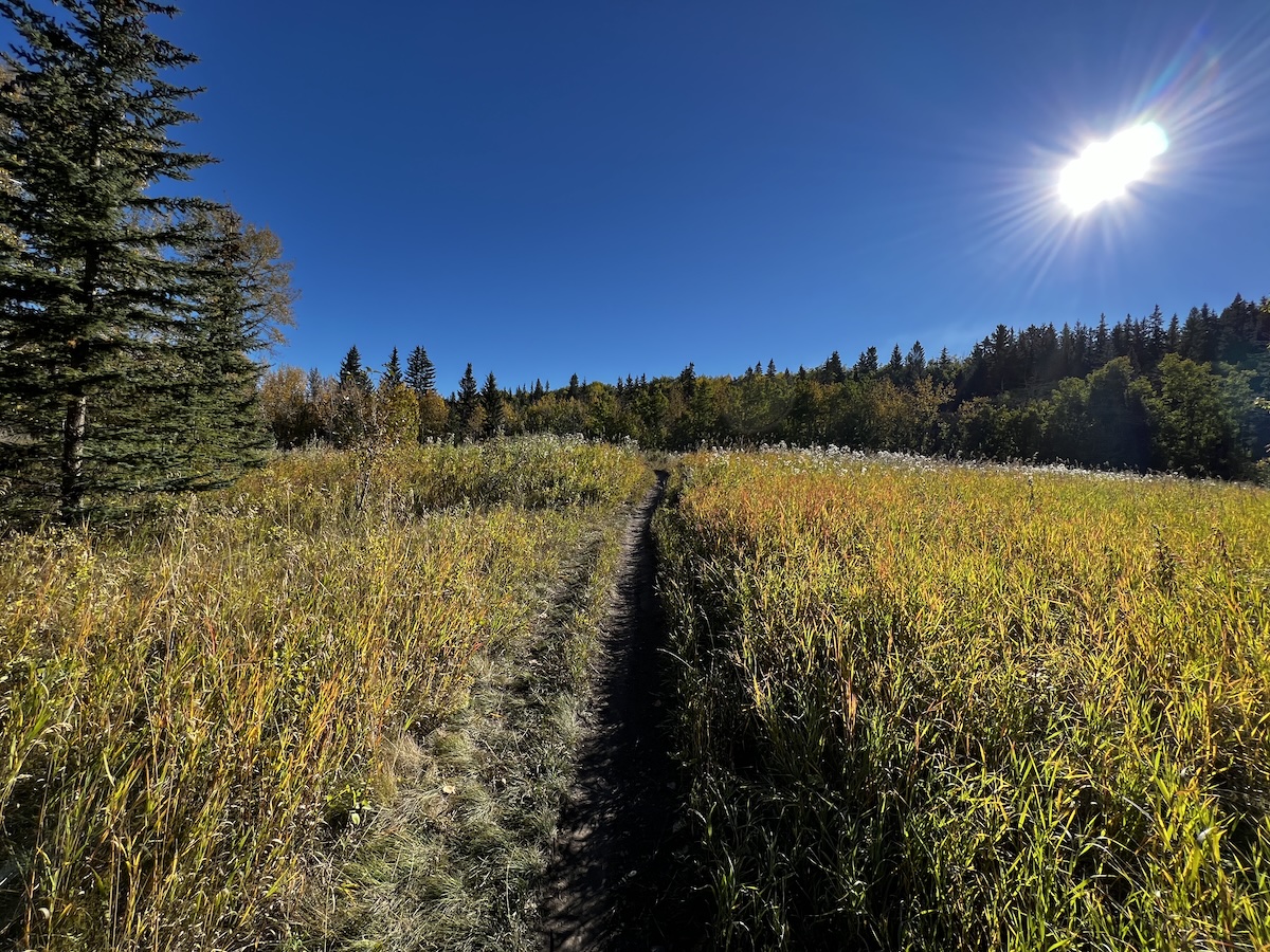
On a November morning with the temperature somewhere near zero and a Chinook arch sitting on the western horizon like a bruise, Fish Creek Provincial Park is almost entirely empty. The paved trail that in July carries cyclists, joggers, and stroller brigades three abreast now belongs to a few dog walkers and the occasional cross-country skier breaking fresh track through a cottonwood stand. The creek itself runs black and cold between banks furred with hoarfrost. A mule deer stands perfectly still in the willows twenty metres away and watches with no particular urgency. It is, in every meaningful sense, a wilderness encounter — the kind of thing you might expect to find a day’s drive from the city rather than eleven kilometres from downtown Calgary, on the southern edge of a metropolitan area of 1.6 million people.
On a November morning with the temperature somewhere near zero and a Chinook arch sitting on the western horizon like a bruise, Fish Creek Provincial Park is almost entirely empty. The paved trail that in July carries cyclists, joggers, and stroller brigades three abreast now belongs to a few dog walkers and the occasional cross-country skier breaking fresh track through a cottonwood stand. The creek itself runs black and cold between banks furred with hoarfrost. A mule deer stands perfectly still in the willows twenty metres away and watches with no particular urgency. It is, in every meaningful sense, a wilderness encounter — the kind of thing you might expect to find a day’s drive from the city rather than eleven kilometres from downtown Calgary, on the southern edge of a metropolitan area of 1.6 million people.
Fish Creek is the second-largest urban park in Canada.1 Most Canadians who have never been to Calgary do not know it exists. Many Calgarians, particularly those new to the city — and there were more new arrivals in 2023 than in any year on record — have not yet found it. The park stretches for nineteen kilometres across the city’s south end, covering roughly 13 square kilometres of river valley, grassland, and wetland. It has more than 100 kilometres of trails.2 On a summer weekend it receives more visitors than some provincial parks. In November it is a secret that the city keeps from itself.
Calgary’s reputation for livability is real and documented. The Economist Intelligence Unit has ranked it among the world’s top ten most livable cities multiple times in the past decade, citing stability, healthcare, culture, and environment alongside infrastructure.3 What those indices rarely specify is the physical basis of that reputation — that beneath the grid of suburban crescents and commercial strips lies more than 8,000 hectares of parkland and natural areas managed by the city, a pathway network longer than any other urban trail system in North America, and a recreational infrastructure that ranges from the two largest YMCAs on the planet to neighbourhood pump tracks for children on bikes. Calgary’s greenness is not incidental to its livability. It is load-bearing.
But the load is increasing. Alberta absorbed roughly 175,000 net new residents in 2023, the large majority settling in Calgary and Edmonton, as this series documented in its previous essay.4 Those residents need parks, trails, and waterways as much as they need housing and schools. The parks are not growing at the same rate as the population. The trails are not lengthening. The prairies and coulees that make Fish Creek and Nose Hill ecologically significant cannot be manufactured. What the city has built over five decades of deliberate investment in green infrastructure is, for the first time in recent memory, under pressure that policy and budget alone may not resolve.
This essay is about what Calgary has, what makes it remarkable, who gets access to it, and what threatens it.
Part A: The Arithmetic of a Green City
Eight thousand hectares is a number that requires context to land. The city of Calgary covers approximately 825 square kilometres, which means parkland and natural areas account for roughly 10 percent of the city’s total land area.5 Spread evenly across the population, that would represent approximately five square metres of parkland per person — not a generous figure by European standards, but Calgary’s park system is not evenly spread, and the comparison to European cities misses the point. What Calgary has built is not a collection of manicured squares and ornamental gardens but a system of functional ecological landscape embedded within the urban fabric.
The city manages these spaces with what amounts to a deliberate philosophical split. Approximately half the park system consists of what planners call manicured parks — sports fields, programmed green spaces, community gardens, deliberately planted landscapes. The other half is classified as natural areas: river valleys, coulee systems, remnant prairie grasslands, and wetland complexes that are managed primarily for biodiversity conservation and ecological function.6 This is an unusual ratio for a North American city of Calgary’s size, and it reflects a planning history that, for all its contradictions, took seriously the value of the landscape it was building into.
Sources: City of Calgary Parks & Recreation; Alberta Parks. Fish Creek is a provincial park; all others are city-managed. Weaselhead Natural Area managed jointly with Tsuu T'ina Nation. Areas are approximate.
Fish Creek and Nose Hill together account for a disproportionate share of the ecological value within that system. Fish Creek’s river valley and associated uplands preserve a river corridor that predates the city’s settlement — cottonwoods, native shrubs, wetlands, and the creek itself, which drains a watershed extending well into the foothills west of Calgary. Nose Hill is something rarer still: an 11-square-kilometre plateau of Rough Fescue grassland rising from the northwest quadrant of the city to a height that gives unobstructed views in all directions.7 Rough Fescue prairie is among the most endangered grassland ecosystems in Canada, having been broken, cultivated, or overgrazed across most of its historic range. The fact that a viable remnant of it sits within the city limits of a major Canadian metropolis, accessible by public transit, and preserved through active management, is an ecological accident that the city has gradually learned to treat as an asset.
The pathway network that connects these spaces — and links them to dozens of smaller parks, river corridors, and neighbourhood green spaces — runs to more than 1,000 kilometres of paved and unpaved trails.8 This is consistently cited as the longest connected urban pathway system in North America, a distinction Calgary has held for long enough that it has become part of the city’s self-image in the way that Chicago identifies with its lakefront or Vancouver with its seawall. The comparison is apt. Like those systems, Calgary’s pathways are genuinely democratic infrastructure: free to use, maintained year-round, and connecting communities across the socioeconomic spectrum of the city.
The connectivity is not accidental. The city’s park classification system explicitly distinguishes between “core habitat” — large, ecologically significant areas like Fish Creek and Nose Hill — and “stepping stones,” the smaller neighbourhood parks and natural areas that function as movement corridors for wildlife and as recreational connectors for residents.9 In ecological terms, the city has built a landscape mosaic rather than a collection of isolated green patches. A coyote moving from the Bow River valley to Nose Hill crosses residential streets but does not lose access to habitat. A child cycling from a northwest community to a river pathway does not lose the pathway. The connections are imperfect and increasingly stressed by infill development at the urban edge, but the intent is present in the city’s planning documents and, more importantly, in the landscape itself.
Part B: The Hidden Geography
Not everyone who lives in Calgary knows where the Twelve Mile Coulee is. The name belongs to a natural area in the northwest that follows a coulee system — one of the dry, grass-lined valleys that cut through the prairie plateau before draining into the Bow or Elbow River systems — for several kilometres through communities that most Calgarians, even those who live nearby, could not precisely locate on a map. It is not heavily promoted. It has no interpretive centre. It is, in the truest sense, a neighbourhood resource: a place known to the people who live within walking distance and largely invisible to everyone else.
The hidden premium. Calgary’s ecological value is disproportionately concentrated in places that receive the least promotional attention — coulee systems, remnant grasslands, and river flats that appear on no visitor itinerary but deliver the majority of the city’s biodiversity services.
Twelve Mile Coulee is one of dozens of such spaces scattered through the city, each known to its immediate community and largely unknown beyond it. Carburn Park, in the southeast, occupies a former gravel pit that has been allowed to revert to riparian habitat — cottonwoods, willows, and a shallow lagoon that serves as waterfowl habitat. It is used heavily by nearby residents and almost never mentioned in civic promotion. The Botanical Gardens of Silver Springs, a volunteer-maintained garden space in a northwest community, operates without city marketing support and serves a devoted local constituency that maintains it through hundreds of hours of contributed labour annually.10
These spaces matter in a specific way that large parks do not. Fish Creek and Nose Hill require travel. They are destinations that Calgarians visit deliberately. The coulee systems, the neighbourhood natural areas, the small wetland pockets, and the riparian corridors are ambient — they are the nature that residents encounter in daily life, on the route to school, during the walk to the grocery store, in the morning before getting in the car. The research on urban health outcomes consistently finds that it is this ambient access to greenery — not just the availability of a large park somewhere in the city — that drives the mental health and physiological benefits associated with urban nature.11
The micro-recreational infrastructure reflects the same logic. Calgary’s 35 outdoor winter hockey rinks — maintained by the city and supplemented by hundreds of volunteer-flooded community rinks — distribute recreational access through the residential fabric of the city rather than concentrating it in a few facilities.12 Pump parks, which are the small concrete or asphalt tracks designed for cyclists on BMX-style bikes, have been installed throughout the city, including in communities that historically had minimal dedicated cycling infrastructure. More than 1,000 playgrounds serve the city’s children, with the notable addition, in recent years, of more than 30 accessible playgrounds designed to serve children with mobility limitations.13 Spray parks function as the democratic summer equivalent of the private lake amenity — free, public, distributed through working-class and middle-income communities rather than concentrated in expensive master-planned developments.
At the mega-facility end of the spectrum, Calgary operates two structures that, by floor area, qualify as the largest YMCAs in the world. The Brookfield Residential YMCA at Seton, in the city’s southeast, and the Shane Homes YMCA at Rocky Ridge, in the northwest, are not just community recreation centres but civic institutions with programming, childcare, and social services that extend well beyond the gym floor.14 Their size is an expression of Calgary’s suburban growth pattern — communities built far from the urban core that need anchor institutions to function as something more than dormitory suburbs — and their YMCA governance model makes them financially accessible to low-income residents in ways that purely private fitness facilities would not be.
The recent growth of what Calgary cycling advocates have begun calling car-free recreation deserves attention here, because it represents a genuine shift in how a portion of the city’s residents think about recreational access. The C-Train, Calgary’s light rail network, reaches from the southern suburb of Somerset to the northwest communities near the YMCAs, with branches serving the northeast and the city centre. Cross-country skiing at Shaganappi Golf Course — a municipal course on the western edge of the inner city that grooms ski trails in winter — is accessible by transit from most of the city.15 The growing practice of using the C-Train for recreational access, rather than car-dependent trips to mountain ski areas, reflects both an environmental value and an economic one: a day of cross-country skiing at Shaganappi costs a transit fare and a trail pass. A day at a mountain resort costs several hundred dollars in gas, lift tickets, and food.
Part C: Nature as Infrastructure
For most of the twentieth century, city governments in North America treated parks as amenities. They were nice to have, politically popular, and broadly beneficial to property values in their vicinity. But they were not, in the accounting sense, load-bearing. Roads, water systems, transit, and utilities were infrastructure. Parks were decoration.
Calgary has formally abandoned that framework. The city’s Natural Infrastructure Blueprint, developed with Earth Economics and adopted as a policy document, places natural assets — prairies, wetlands, river corridors, tree canopy — on an explicit continuum with engineered infrastructure like green roofs, permeable pavement, and bioswales.16 In this framework, the Rough Fescue grassland on Nose Hill is not a scenic backdrop. It is a stormwater management system, a carbon sequestration facility, an air filtration network, and a thermal buffer against urban heat — all without requiring an operating budget beyond the cost of keeping cattle and invasive species out of it.
Nature as load-bearing. Calgary’s Natural Infrastructure Blueprint is not a rhetorical exercise. It is the basis on which the city calculates the financial value of retaining natural areas against development pressure — and the basis on which it justifies spending on restoration when those areas degrade.
Green roofs are the clearest example of where the engineered and natural ends of the continuum converge into something that is simultaneously infrastructure and ecology. As a drought-prone city with significant precipitation variability — Calgary receives most of its annual moisture in a relatively compressed spring and early summer window, punctuated by Chinook-driven evaporation events throughout the year — stormwater management is a genuine engineering challenge. Green roofs address it directly. Studies cited in the city’s policy work find that vegetated roof systems retain up to 67 percent of stormwater that would otherwise enter the drainage system, rising to as much as 92.6 percent during extended dry periods when the plants are most moisture-stressed and therefore most actively absorbing precipitation.17 At scale, across a commercial district or a dense mixed-use neighbourhood, this is not a marginal contribution to the city’s stormwater capacity. It is, in the language of infrastructure planning, a significant capital asset.
The city evaluates these investments using a Triple Bottom Line Cost-Benefit Analysis framework that accounts simultaneously for financial outcomes (construction cost, maintenance cost, asset life), social outcomes (health benefits, recreational access, community cohesion), and environmental outcomes (flood avoidance, carbon sequestration, biodiversity support).18 This framework matters because it changes the comparison. A conventional stormwater pipe, evaluated on financial cost alone, may appear to outperform a green roof or a restored wetland. When the full TBL account is run — including the health costs avoided by flood prevention, the air conditioning savings from reduced urban heat, the mental health benefits of green space access, and the biodiversity value of restored habitat — the green infrastructure option frequently performs better than the conventional alternative.
This is not theoretical. The Bow and Elbow Rivers, which converge in downtown Calgary, have flooded the city catastrophically in living memory. The 2013 floods caused an estimated $6 billion in total economic losses, of which a substantial portion fell on the city itself in infrastructure damage and emergency response costs.19 The post-flood investment in riparian area management, including the Riparian Action Program that manages waterway buffers throughout the city, is partly an environmental program and partly a risk management strategy. Preserving and restoring the natural flood attenuation capacity of river corridors — the willow and cottonwood stands, the wetland complexes, the gravel bars and oxbows that slow and spread flood flows — reduces the peak discharge that reaches the engineered flood control infrastructure downstream. Every hectare of functioning floodplain is a hectare that does not have to be replicated in concrete.
Active management of natural areas is a continuous and expensive commitment, and one that the city’s planning documents acknowledge does not always receive adequate budget allocation. Urban natural areas degrade predictably over time under the combined pressure of heavy public use and surrounding development. Trails widen. Slopes erode. Invasive plants establish themselves along disturbance corridors. The native grassland on Nose Hill, if left unmanaged, would gradually transition toward a different plant community dominated by species that arrived with European settlement. Preventing that transition requires annual management interventions — targeted grazing by cattle to replicate the ecological role historically played by bison, mechanical removal of invasive plants, slope stabilization along eroding trail edges — that are easily cut from a budget under fiscal pressure and whose costs, when deferred, compound into much larger restoration expenses.20
Part D: The Health Account
The case for urban green space as a public health investment is not new, but it has become substantially more quantified in the past decade. The Urban Institute, drawing on a substantial body of epidemiological and public health research, describes the benefits of park access across four dimensions: physical health, mental health, social cohesion, and environmental resilience.21
The physical health dimension is the most straightforward to quantify. Access to parks and trails is strongly associated with higher levels of physical activity in the surrounding population, and physical activity is a primary modifier of cardiovascular disease risk, type 2 diabetes incidence, obesity prevalence, and all-cause mortality. The effect sizes are not small. Studies consistently find measurable differences in health outcomes between populations with high and low proximity to usable green space, controlling for socioeconomic status and other confounders.22 In the context of a public health system that bears the downstream costs of those chronic conditions, the park system is not just recreation infrastructure — it is preventive medicine delivered at neighbourhood scale.
Mental health is both harder to quantify and more dramatically affected by green space access than the physical health literature initially suggested. Research consistently finds associations between urban green space exposure and reduced incidence of depression and anxiety, improved stress recovery, better cognitive function in children, and lower rates of psychological distress across the adult population.23 The mechanisms are multiple: direct psychological restoration from natural environments, increased physical activity with its well-established mental health benefits, increased social interaction facilitated by shared public spaces, and reduced exposure to noise and air pollution. For a city in which a significant portion of the population arrived in the past two years, often without established social networks, the mental health dimension of park access is not a secondary consideration.
Social cohesion — the third dimension — is perhaps the least intuitive of the four. Parks are places where strangers become neighbours. The hockey rink in December, the spray park in August, the dog path along the river in every season: these are the sites of the low-intensity social contact that urban sociologists identify as critical to the formation of community in cities built around car travel and private space. Calgary’s dispersed park system, with its emphasis on neighbourhood-scale infrastructure alongside destination parks, is well structured to support this function. A pump track in a northwest community creates a shared space for children and parents who might otherwise remain strangers behind their respective garage doors.
Environmental resilience — the fourth dimension — connects back to the natural infrastructure analysis. Parks and natural areas buffer their surrounding neighbourhoods against temperature extremes, reduce flood risk, improve air quality, and in some configurations serve as noise barriers. The urban heat island effect, which raises temperatures in densely built areas by as much as several degrees Celsius relative to surrounding landscapes, is measurably attenuated in neighbourhoods with mature tree canopy and natural ground cover.24 In a city that already operates at the dryer and warmer end of the Canadian prairie climate, this buffering effect is not a luxury. It is a component of habitability.
The aggregate economic value of these benefits, when calculated using the TBL framework the city applies to infrastructure investment decisions, is substantial. Averted healthcare costs, reduced energy consumption, reduced stormwater infrastructure requirements, and higher property values in park-adjacent neighbourhoods all contribute to a return on the investment in parkland that, when properly accounted, significantly exceeds the cost of land acquisition and maintenance. The difficulty is that these returns accrue diffusely — to the provincial health system, to individual homeowners, to the municipal stormwater utility — while the costs of acquiring and maintaining parkland are borne directly by the city’s capital and operating budgets. This accounting mismatch is one reason park systems are consistently underfunded relative to their contribution to urban welfare.
Part E: Who Gets In
Calgary has a two-tiered relationship with water.
Across the city’s southern and southeastern quadrants, roughly a dozen master-planned communities have been built around man-made lakes. These are not public amenities. They are restricted recreational infrastructure, accessible only to residents of the associated community who pay homeowners’ association fees for the privilege of lake access. The lakes — typically a dozen or more hectares of open water with sand beaches, boat launches, and recreational facilities — function as neighbourhood amenities for what are, by Calgary standards, affluent residential developments.25 From the air, the lakes look like public parks. From the street, they are fenced.
The private lake paradox. Calgary’s most photographed urban recreational amenity is unavailable to the majority of Calgarians. The lake communities represent a privatisation of recreational infrastructure that the city’s public park system explicitly exists to counterbalance — but does not fully succeed in doing.
This arrangement is legal, established, and unlikely to change for the existing communities, where property values are substantially tied to lake access and residents have both legal title to the infrastructure and political influence over the communities that surround it. It is, however, in direct tension with the principle that motivates the rest of Calgary’s park investment: that access to quality green and blue space should be a civic right rather than a fee-based privilege.
The tension has a longer North American history. Research on equitable park access consistently finds that proximity to quality green space in American cities follows racial and socioeconomic lines, with lower-income and minority communities significantly underserved relative to their wealthier counterparts. The mechanism is partly historical — mid-twentieth century redlining and exclusionary zoning concentrated development in areas with poor green space access, and those patterns have proved durable — and partly contemporary, reflecting the higher land costs in green-adjacent areas and the political economy of park investment, which tends to direct resources toward areas with organized advocacy capacity.26
Calgary does not have a racial history of redlining in the American sense, but it does have a socioeconomic geography in which newer, lower-income communities at the urban periphery tend to be underserved by green space relative to established inner-city and northwest communities where park land was acquired decades ago at lower cost. The infrastructure has accumulated unevenly. The older parts of the city, developed when land was cheap and planning was more willing to set large areas aside, have more green space per capita than the growth communities of the south and northeast, where density has prioritized housing and commercial development.
The city has responded to this inequity with a collection of interventions that range from useful to insufficient. The Fee Assistance Card program provides low-income Calgarians with subsidized access to transit, city recreational facilities, and YMCA memberships, significantly reducing the cost barrier to the major indoor recreation infrastructure.27 This is a meaningful intervention for families priced out of private fitness facilities, and it extends to the world-class YMCA campuses at Seton and Rocky Ridge that would otherwise cost several hundred dollars annually per family member to access.
What the Fee Assistance Card cannot provide is proximity. A family in the northeast, relying on transit, faces a longer journey to Fish Creek Provincial Park than a family in Shawnessy or Cranston, for whom the park is a short bike ride or walk. The social science on park access consistently finds that distance is the binding constraint — not cost. People use parks near their homes at far higher rates than parks that require a trip, regardless of the quality of the distant park or the cost of the trip.28 The pathway network partially compensates for this, giving transit-accessible park entry points throughout the city, but the underlying geography of park distribution remains unequal.
The growing car-free recreation movement addresses part of the problem from a different angle. The C-Train’s geographic reach, combined with the pathway system’s connections to train stations, makes a substantial portion of Calgary’s recreational infrastructure accessible without a car. Cross-country skiing at Shaganappi, river valley cycling, neighbourhood park access, Beltline mural routes — these are forms of recreation that are genuinely available to a transit-dependent resident in a way that, say, a day at Lake Louise is not. The movement is small, concentrated among environmentally motivated inner-city residents, and not yet seriously integrated into how the city communicates about recreational access. But it represents a model of green space use that is more equitable, lower-carbon, and more suited to the transportation reality of a large fraction of new Calgarians than the car-dependent, destination-oriented model that has historically dominated.
Part F: The Pressure Points
The most useful way to understand the pressure on Calgary’s green infrastructure is not to look at any single threat but to recognize that several reinforcing pressures are operating simultaneously on a system that was designed with a smaller city in mind.
The first pressure is simply demographic. This series has documented at length what happened to Alberta’s population in 2022 and 2023: an extraordinary surge of interprovincial and international migration that added people at a rate the province had not seen in decades. The large majority of those arrivals settled in Calgary and Edmonton, and Calgary’s population is now approaching 1.6 million. Each new resident makes a marginal additional claim on the park system — more feet on the Fish Creek trails, more users at the spray parks, more dogs in the off-leash areas, more cyclists on the pathway network. The claims are individually small and collectively substantial.
Population figures: Statistics Canada census (2011, 2016, 2021) with municipal estimates for inter-censal years; 2022–2024 from City of Calgary municipal census and Provincial estimates. Parkland per capita derived from city-reported natural area totals (~8,000 ha across the study period, with modest additions) divided by annual population. Figures are modelled estimates illustrating structural trend; exact year-on-year additions are not publicly reported at annual resolution.
The pathway network does not lengthen itself in proportion to population growth. Natural areas cannot be expanded — a coulee is where it is, and the residential development that has surrounded it over the past thirty years has defined its permanent boundaries. Fish Creek Provincial Park is a provincial jurisdiction, not a city asset, which complicates the relationship between Calgary’s growth management and the park’s capacity management. The park has no formal user-capacity limits, and on summer weekends the parking lots at its major access points fill by mid-morning.29
The second pressure is developmental. Calgary’s growth strategy has increasingly emphasized infill development and densification of established communities, which brings residents closer to existing parks and therefore increases their use intensity. This is, from a planning perspective, a desirable outcome — park access improves for densifying communities, and the urban footprint expands more slowly than under pure suburban sprawl. But it also means that the neighbourhood parks and natural area corridors within established communities are being asked to serve more people without receiving proportional investment in maintenance, programming, or capacity.
The edges of the natural areas are where the developmental pressure is most visible. The buffer zones between Fish Creek and adjacent residential development have been eroded, in some sections, to a narrow band of trees. The same pattern is visible at natural area edges throughout the city — the boundary between maintained parkland and private land is often defined by a chain-link fence and a mown strip rather than the graduated transition of shrubs and rough vegetation that would provide genuine ecological buffering. Development approvals that bring housing to the very edge of natural area boundaries, even when they comply with setback requirements, reduce the ecological functionality of the adjacent parkland.
The third pressure is climatic. Calgary’s position at the rain shadow of the Rocky Mountains makes it one of the driest major cities in Canada, and the climate projections for the Canadian prairies consistently point toward warmer and drier conditions through the coming decades.30 Droughts that were once decadal events are becoming more frequent. The Rough Fescue grassland on Nose Hill evolved under periodic drought conditions and is reasonably resilient, but the cottonwood and willow communities in the river valleys are more water-dependent and more vulnerable to prolonged low-flow and high-temperature events. Tree mortality in urban natural areas, which has been observed in multiple Calgary coulee systems in recent dry summers, creates gaps in the canopy that allow invasive plant establishment and accelerate the degradation that requires costly active management to reverse.
The fourth pressure is the least visible: the gradual biological degradation of natural areas under sustained heavy use. The trails in Fish Creek’s most popular sections are, in places, three times as wide as they were a decade ago, as users have spread onto adjacent vegetation to avoid muddy sections or simply because the paths are overcrowded. Erosion follows trail widening. Exposed soil becomes a vector for invasive plant establishment. The slope faces along some of the coulee systems within the city have required engineered stabilization — jute netting, planted root systems, occasional concrete or timber reinforcement — because the natural vegetation that held them has been trampled away. This is not a failure of park design. It is a straightforward consequence of asking a fixed area to absorb an increasing number of visitors.31
The city’s response to this degradation is active management: the targeted cattle grazing that mimics bison on the Nose Hill grasslands, the habitat restoration plantings that follow slope stabilization work, the trail rerouting that closes eroded paths and allows vegetation recovery. These interventions work. The question is whether the budget to sustain them will keep pace with the degradation that an accelerating population is generating. In the recent history of municipal budget cycles, natural area maintenance has been among the first items reduced in fiscal restraint exercises. The effects of those reductions are not immediately visible — nature degrades gradually — which makes them politically easier to absorb than, say, a road that is not repaired. But the compounded effect of deferred natural area maintenance is a park system that is measurably less functional than it would have been under consistent investment.
The lake communities add an additional layer of complexity to the equity dimension of this pressure. As the public park system absorbs more users and shows more signs of stress — crowded trails, eroded slopes, degraded natural areas — the residents of private lake communities continue to enjoy recreational water access that is, by definition, not subject to those pressures. The lakes are managed for their fee-paying users, not for a public that grows by 40,000 or 50,000 people in a year. This is not an argument against the legal rights of lake community residents. It is an argument about what the pattern reveals: that the people with the most resources have engineered themselves out of dependence on the public system, and the public system is absorbing the full weight of growth.
Part G: The Pathway Forward
There is a photograph that circulates among Calgary urban planning advocates — a satellite image of the city taken in early spring, after the snow has retreated but before the canopy has leafed out, that shows the river valley system in stark detail. The Bow River and its tributaries carve green fingers through the city’s grid, connecting Fish Creek in the south to Bowness in the northwest, threading through the downtown core between the towers of the financial district, and reaching toward the foothills in the west. From the air, the city looks like it was built in a forest. From the street, much of that forest is invisible to the residents who live within blocks of it.
The case for Calgary’s green infrastructure is not that it is perfect or equitably distributed or immune to the pressures that are beginning to show in eroded trails and stressed cottonwood stands. It is not. The case is that Calgary has, over fifty years of park investment, built something genuinely valuable that is now at risk of being taken for granted precisely because it was built so successfully that it became part of the background.
The pathway network did not appear because Calgary is naturally green. It appeared because successive generations of planners, advocates, and politicians decided that a city could be measured by what its residents can do without getting in a car. The reserve of Rough Fescue on Nose Hill did not survive because no one wanted to develop it. It survived because the city chose, repeatedly and under development pressure, to protect it. Fish Creek Provincial Park exists because a provincial government, in 1973, agreed to designate as parkland a river valley that developers had other plans for. These choices were made. They can be unmade.
The hidden cost of visibility. Calgary’s green infrastructure is both its least-promoted asset and its most important one. The risk is not that it will be destroyed in a single decision, but that it will be degraded incrementally, by a thousand budget cuts and development approvals, each individually defensible, whose cumulative effect is a park system that works less well for more people.
The population surge of 2023 has made the stakes visible in a way they were not before. When Fish Creek’s parking lots fill by ten in the morning, and Nose Hill’s trails are crowded enough that dog walkers need to negotiate passage, and the pathway along the Bow carries so many cyclists that it functions more like a road than a trail, the question of capacity becomes impossible to ignore. Calgary is not the first North American city to face this question. The cities that have answered it well — Portland, Minneapolis, many European comparators — have consistently made the same choice: they invested ahead of demand, they protected land before it was needed, and they distributed access equitably rather than allowing the market to concentrate it in areas that could already afford it.
The two-tiered model of water access, with private lakes for those who can pay and spray parks and stormwater ponds for those who cannot, is a microcosm of the broader challenge. It is the natural endpoint of a market logic applied to a public good. The Fee Assistance Card is a patch on a structural problem, and the car-free recreation movement — which asks people to opt into a mode of recreation that is genuinely more equitable and environmentally sound — will not reach the Calgarians who most need expanded access without deliberate public investment in the connections between transit and parks.
What Calgary has is extraordinary. It is also, in the specific ways documented here, fragile. The cottonwoods along Fish Creek have been there longer than the city. They will not be there if the river floods more frequently, the water table drops, and the foot traffic around their root zones continues to compact the riparian soil. The Rough Fescue on Nose Hill has survived a century of urban encroachment. It will not survive another century of insufficient management funding. The pathways will carry more cyclists than they were designed for until they don’t.
The mule deer in the cottonwood stand on that November morning was not waiting for a planning decision. It was simply there, in the space the city had, through accumulated choices across decades, left open for it. The question is whether the city, as it keeps growing, keeps making those choices — or stops noticing that there was ever a choice to make.
References
Alberta Parks. 2024. “Fish Creek Provincial Park.” Government of Alberta. https://www.albertaparks.ca/parks/kananaskis/fish-creek-pp/
Calgary Journal. 2022. “How Green Roofs Help Grow a Sustainable Calgary.” https://calgaryjournal.ca/2022/04/22/how-green-roofs-help-grow-a-sustainable-calgary/
Calgary Journal. 2023. “Embracing Car-Free Adventures in Calgary.” The Green Podcast. https://calgaryjournal.ca/2023/02/10/the-green-podcast-embracing-car-free-adventures-in-calgary/
City of Calgary. 2023. “Natural Parks and Wetlands.” Parks and Recreation. https://www.calgary.ca/parks/natural-environment/natural-parks-wetlands.html
City of Calgary. 2023. “Pathway and Bikeway Network.” Transportation. https://www.calgary.ca/transportation/tp/cycling/cycling-routes-and-pathways/pathways.html
City of Calgary. 2024. “Fee Assistance.” Access to Recreation. https://www.calgary.ca/recreation/subsidized-recreation/fee-assistance.html
Earth Economics. 2019. Natural Infrastructure Blueprint for The City of Calgary. Prepared for the City of Calgary. Tacoma, WA: Earth Economics. https://www.eartheconomics.org/calgary
Economist Intelligence Unit. 2023. Global Liveability Index 2023. London: Economist Group.
Environment and Climate Change Canada. 2022. Canada’s National Adaptation Strategy: Building Resilient Communities and a Strong Economy. Ottawa: ECCC. https://www.canada.ca/en/environment-climate-change/news/2022/11/canadas-national-adaptation-strategy.html
Every Day Tourist. 2023. “Recreational Opportunities Make Calgary Most Livable City in the World.” https://www.everydaytourist.ca/edmonton-tourist/2023/calgary-most-livable
Gidlöf-Gunnarsson, Anita, and Evy Öhrström. 2007. “Noise and Well-Being in Urban Residential Environments: The Potential Role of Perceived Availability to Nearby Green Areas.” Landscape and Urban Planning 83 (2–3): 115–126. https://doi.org/10.1016/j.landurbplan.2007.03.003
Government of Alberta. 2013. 2013 Alberta Floods: Provincial Recovery Framework. Edmonton: Government of Alberta. https://www.alberta.ca/alberta-flood-recovery
Green Calgary Association. 2022. Hidden Gems of Calgary, Part 1. Calgary: Green Calgary. https://greencalgary.org/hidden-gems/
Statistics Canada. 2024. “Population Estimates, Quarterly.” Table 17-10-0009-01. https://www150.statcan.gc.ca/t1/tbl1/en/tv.action?pid=1710000901
Urban Institute. 2016. The Health Benefits of Parks and Their Economic Impacts: A Review of the Literature. Washington, DC: Urban Institute. https://www.urban.org/research/publication/health-benefits-parks-and-their-economic-impacts
YMCA Calgary. 2024. “Shane Homes YMCA at Rocky Ridge.” https://www.ymcacalgary.org/locations/shane-homes-ymca-at-rocky-ridge/
-
Fish Creek Provincial Park is managed by Alberta Parks and encompasses approximately 1,348 hectares within Calgary’s city limits, making it the second-largest urban park in Canada after Rouge National Urban Park in Toronto. The park was designated in 1973 following advocacy efforts that prevented planned residential and commercial development in the river valley corridor. ↩
-
The 100-kilometre trail figure encompasses both paved and unpaved trails within Fish Creek Provincial Park proper, including connections to the city’s pathway network at multiple access points along the park’s northern and southern edges. Visit Calgary tourism materials cite this figure; exact kilometre counts vary slightly depending on whether seasonal trail segments are included. ↩
-
The Economist Intelligence Unit’s Global Liveability Index evaluates cities across five categories: stability, healthcare, culture and environment, education, and infrastructure. Calgary has placed in the global top 10 multiple times since 2015, typically ranking third or fourth behind Vienna and Copenhagen/Zurich. The methodology weights recreational and environmental infrastructure within the culture and environment category. ↩
-
See “Alberta Calling,” Alberta in Context series, essay 8 (March 2026). Net interprovincial in-migration to Alberta in calendar 2023 is estimated at approximately 72,000; international migration added a further 100,000+ residents, with Calgary absorbing the majority of both flows. ↩
-
Calgary’s total land area of approximately 825 km² (82,500 hectares) and the 8,000+ hectare parkland figure yield a rough park ratio of approximately 9.7 percent. This figure excludes the Glenmore Reservoir watershed, private golf courses, and school grounds, which together add significant additional green space to the urban landscape. The City of Calgary Parks department manages the 8,000-hectare figure as the basis for natural area and park planning. ↩
-
City of Calgary Parks: Natural Parks and Wetlands (City of Calgary municipal policy document). The 50/50 split between manicured and natural areas is an approximate characterization used in city planning documents; the precise ratio varies with classification methodology. ↩
-
Nose Hill Park’s area of 11 km² (1,100 hectares) makes it one of the largest urban remnant prairies in Canada. The Rough Fescue grassland community is a nationally rare ecosystem; Alberta’s Central Parkland region once supported extensive Rough Fescue prairie that has been reduced to scattered fragments by agriculture and urban development. ↩
-
The 1,000-kilometre pathway figure is the city’s own cited figure for its Pathway and Bikeway network, which includes both paved multi-use trails and designated on-street bikeways. The network is frequently described in city promotional materials as the longest urban pathway system in North America, though methodological differences in what counts as “connected” pathway make precise inter-city comparison difficult. ↩
-
Natural Infrastructure Blueprint for The City of Calgary (Earth Economics, prepared for the City of Calgary). The “core habitat” and “stepping stone” classification system is drawn from landscape ecology’s patch-corridor-matrix model and is used in Calgary’s park and natural area management framework. ↩
-
Green Calgary Association: Hidden Gems of Calgary, Part 1. The Botanical Gardens of Silver Springs is a community-maintained space that receives no dedicated city marketing budget; the volunteer labour model is characteristic of several neighbourhood-scale green spaces in Calgary that persist through community stewardship rather than municipal programming. ↩
-
The distinction between ambient access (incidental daily exposure to green space) and destination access (deliberate visits to large parks) is drawn from research by Gidlöf-Gunnarsson and Öhrström (2007) and subsequent urban health literature. Ambient greenness, measured as visible vegetation cover within 250–500 metres of a residence, shows stronger associations with self-reported well-being than distance to the nearest large park. ↩
-
The City of Calgary operates 35 outdoor leisure ice pads — hockey rinks maintained and flooded by city crews — across the city. Additional volunteer-flooded rinks, maintained by community associations using city water access, number in the hundreds in a typical winter; the count varies with temperature conditions and volunteer capacity. ↩
-
Recreational Opportunities Make Calgary Most Livable City in the World (Every Day Tourist). The 1,000+ playground figure and 30+ accessible playground figure are drawn from city park inventory data. The accessible playground program, which installs rubberized surfaces, wheelchair-accessible equipment, and sensory play elements, has expanded significantly since 2018. ↩
-
The Brookfield Residential YMCA at Seton opened in 2022 at approximately 240,000 square feet, and the Shane Homes YMCA at Rocky Ridge, which opened in 2017, is approximately 250,000 square feet. Both are claimed to be the largest YMCA facilities in the world by floor area at the time of their respective openings. ↩
-
The Green Podcast: Embracing Car-Free Adventures in Calgary (Calgary Journal). Shaganappi Golf Course’s winter cross-country ski trail grooming is operated by the City of Calgary Parks and Recreation department; the course’s proximity to the CTrain’s 45th Street station makes it one of the most transit-accessible winter recreation sites in the city. ↩
-
Natural Infrastructure Blueprint for The City of Calgary (Earth Economics). The continuum concept positions natural assets alongside built infrastructure in a single planning and valuation framework, requiring city departments to account for natural asset value in capital planning decisions. ↩
-
How Green Roofs Help Grow a Sustainable Calgary (Calgary Journal). The 67 percent and 92.6 percent stormwater retention figures are drawn from North American green roof performance studies cited in the article; retention rates vary significantly with substrate depth, plant selection, and antecedent moisture conditions. ↩
-
The Triple Bottom Line Cost-Benefit Analysis framework is described in the Natural Infrastructure Blueprint as the city’s standard tool for evaluating natural infrastructure capital investments. It represents a significant methodological shift from conventional financial cost-benefit analysis and has been applied to decisions including wetland restoration, riparian buffer management, and green roof incentive programs. ↩
-
The 2013 Alberta floods, which caused widespread damage in Calgary and surrounding communities, are among the most costly natural disasters in Canadian history. Total economic losses are estimated at $6 billion, with insured losses alone exceeding $1.7 billion. The Government of Alberta spent approximately $550 million in immediate flood relief and recovery. The floods prompted significant investment in Calgary’s riparian area management and flood risk reduction programs. ↩
-
City of Calgary Parks: Natural Parks and Wetlands. The observation that urban natural areas degrade under heavy use and development pressure, and require active management to maintain ecological function, is a consistent finding in urban ecology literature. The specific interventions described — targeted grazing, slope stabilization, invasive plant removal — are documented in Calgary’s park management planning documents. ↩
-
Urban Institute: The Health Benefits of Parks and Their Economic Impacts. The four-dimension framework (physical, mental, social, environmental) is the analytical structure used in this report, which synthesizes epidemiological research on park access and health outcomes. ↩
-
The association between green space proximity and physical activity levels is among the most robust findings in urban health research. Studies consistently find significant associations between park access (typically measured as green space within 300–500 metres of residence) and objectively measured physical activity, independent of socioeconomic status and other confounders. ↩
-
Mental health research on urban green space includes both experimental studies (brief nature exposure and stress recovery) and epidemiological work (long-term green space exposure and mental health outcomes). Associations between residential green space and reduced incidence of depression and anxiety are found across multiple countries and cultural contexts. ↩
-
The urban heat island effect in large North American cities can raise temperatures in densely built areas by 2–5°C relative to surrounding landscapes. Tree canopy provides both direct shading and evapotranspiration cooling; studies in multiple North American cities find measurable temperature differentials between high-canopy and low-canopy neighbourhoods, with the difference concentrated during extreme heat events. ↩
-
Calgary’s lake communities are a distinctive feature of the city’s master-planned residential development history. Approximately a dozen communities have man-made lakes with restricted access; the lakes are owned and managed by homeowners’ associations funded by resident fees. The largest communities include Lake Bonavista (one of the first, established in the 1960s) and newer developments in the southeast. ↩
-
Urban Institute: The Health Benefits of Parks and Their Economic Impacts. The historical relationship between redlining, exclusionary zoning, and unequal park access is well documented in the American context; the mechanism combines discriminatory patterns of park investment in the mid-twentieth century with the compounding effects of land value premiums near green space. ↩
-
The City of Calgary Fee Assistance Card program provides qualifying low-income Calgarians with a card that can be used for transit fares, city recreational facility access (including pools and leisure centres), and YMCA memberships at no or significantly reduced cost. The program is income-tested and delivered through a simple application process. ↩
-
The distance-decay function for park use — the well-documented finding that park visit frequency declines sharply with distance from residence — is one of the most consistent findings in the outdoor recreation literature. Studies typically find that most park use comes from residents within 800 metres on foot (approximately a ten-minute walk) regardless of park quality or programming. ↩
-
Fish Creek Provincial Park is managed by Alberta Parks, which has jurisdiction over visitor management, trail maintenance, and facility operations within the park boundary. The City of Calgary has no direct authority over park capacity management, trail closure, or access point infrastructure, which can create coordination challenges when urban growth increases demand on the provincial facility. ↩
-
Climate projections for the Canadian prairie region, including those from Environment and Climate Change Canada, consistently project warming temperatures and increased precipitation variability through the mid-twenty-first century. For Calgary specifically, projections include more frequent and intense Chinook events, longer dry periods between precipitation events, and increased probability of both drought and intense short-duration rainfall. ↩
-
Trail widening under heavy use is a well-documented phenomenon in urban park management. The mechanism is straightforward: when a trail becomes congested or muddy, users step to the side to pass or avoid the poor surface, gradually expanding the trail width and creating a braided trail system that covers significantly more ground than the original alignment. Soil compaction around tree root zones associated with informal trail use can cause significant root damage and increase tree mortality risk. ↩