Avalanche Country
When Highway 93 North closed between Parker Ridge and Saskatchewan Crossing on February 26, 2026, it looked like a familiar Rockies interruption. It was familiar. But it was also a reminder that the eastern slopes are entering a different hazard regime: one in which classic continental-snow avalanches increasingly overlap with warming-driven wet snow, rockfall, and permafrost thaw.
Prologue: A Familiar Closure, and a Different Kind of Warning
On February 25, 2026, Parks Canada announced that Highway 93 North - the Icefields Parkway - would close beginning at 10 a.m. on February 26 through late afternoon on February 27 between Parker Ridge and Saskatchewan Crossing. The reason was plain enough: a winter storm was forecast to bring as much as 30 centimetres of snow, enough to require avalanche control before the road could be safely reopened.1
In one sense, this was ordinary. The Icefields Parkway is one of the most avalanche-exposed roads in Canada. Parks Canada identifies 38 major avalanche paths along it, and treats closures as a normal part of winter operations rather than an exceptional failure of the system.2 Anyone who travels that road often knows the rhythm: storm, closure, control work, cleanup, reopening.
But ordinary does not mean unimportant. The closure is worth noticing precisely because it reveals something structural about the eastern slopes of the Rockies. These mountains do not produce avalanches in the same way the Coast Mountains do, or the way the high Swiss Alps do. They tend to produce fewer obvious storm-day releases, but a more unnerving kind of instability: thinner snowpacks, colder interiors, weaker basal structure, longer memory. A Rockies snowpack often carries its problem forward. It stores it.
That has been one of the defining features of the 2025-26 avalanche season to date. By early March, Avalanche Canada was warning that many regions in western Canada were dealing with buried persistent weak layers that had become less obvious as they deepened - the classic low-probability, high-consequence problem. The public message was not dramatic; it was worse than dramatic. It was patience.3
This essay is about that kind of mountain hazard: not the spectacular avalanche alone, but the geography that makes it recurring, the snow climate that makes it deceptive, and the warming trend that may now be adding a second instability regime on top of the first. The eastern slopes have always been avalanche country. The question now is whether they are becoming Swiss in a new and more troubling sense.
Scroll through the closure geography below.
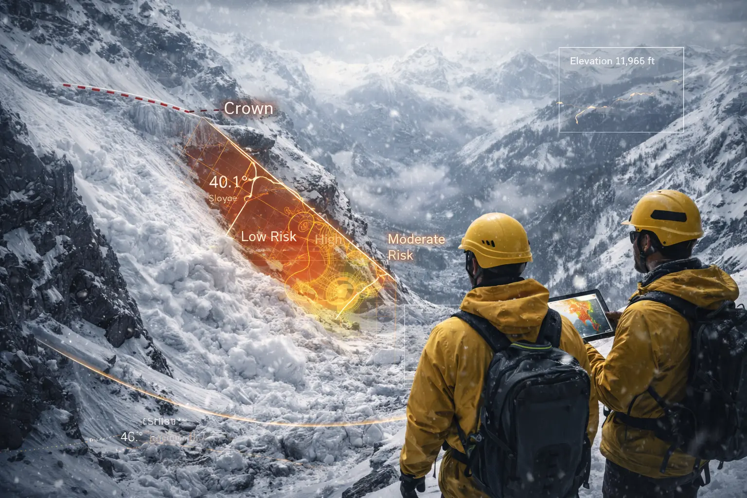
Step 1 - The corridor. The Icefields Parkway threads a narrow mountain trench between Jasper and Banff. That is exactly why it exists, and exactly why it is exposed. Transportation routes seek the lowest line through alpine terrain; avalanche paths seek the same line at the bottom.
Step 2 - The closure segment. On February 26-27, 2026, Parks Canada closed the section between Parker Ridge and Saskatchewan Crossing. This is not random inconvenience. It is one of the most topographically vulnerable links on the road, where start zones sit directly above a route with few alternatives.
Step 3 - The loading plume. The late-February storm approached from the west, crossed the divide, and loaded lee features above the parkway. The blue plume is interpretive rather than literal, but the process is real: modest snowfall, wind transport, and terrain focusing are enough to make a Rockies slope dangerous.
Step 4 - Where the mountain crosses the road. The orange fans indicate approximate runout geometry: broad enough to sweep valley-floor infrastructure, narrow enough to look deceptively manageable when viewed from a vehicle window. This is what makes avalanche control necessary. The hazard is not just upslope. It is where the upslope meets mobility.
Step 5 - Why the eastern slopes behave differently. East of the divide lies the drier continental snow climate of the Alberta side. The purple field marks the broader eastern-slope context: thinner snowpacks, stronger faceting, and a higher chance that weak layers survive long enough to matter weeks later.
Part A: Why the Eastern Slopes Slide
The first thing to understand is that the eastern slopes are not simply “the Rockies.” They are a very particular side of the Rockies.
Moist Pacific air arrives from the west and is forced upward across the cordillera. Much of that moisture is lost before it reaches the Front Ranges and Main Ranges that feed Alberta’s eastern drainages. What remains is a colder, drier, thinner mountain snow climate than the one found farther west in the Columbia Mountains or on the coast. Avalanche Canada describes the Rockies as a continental snow climate: relatively infrequent storms, thinner snow cover, colder conditions, and a strong tendency to form persistent weak layers such as facets and depth hoar.4
That matters because avalanche hazard is not only about how much snow falls. It is about what the snowpack becomes after it falls.
In a maritime range, danger often spikes during or just after storms, then settles comparatively quickly. In the eastern slopes, the opposite problem is common. Long dry spells and strong temperature gradients turn early-season snow near the ground into weak, sugary grains. Later storms bury that weakness beneath a stronger slab. The result is the archetypal Rockies setup: a slope that looks settled, travels quietly for days or weeks, and then fails deeply and widely when the load, temperature, or trigger point is finally right.5
This is why Rockies avalanches can feel intermittent but arrive at full magnitude. Avalanche Canada’s definition of a deep persistent slab is blunt: such avalanches are difficult to predict, often intermittent, and frequently large and destructive.5 The eastern slopes are built for exactly this sort of problem. Their snowpack is often shallow enough that buried weak layers remain within reach of stress. Their start zones are frequently rocky. Their relief is steep enough that once a slab fails, it can run a very long way.
The geography amplifies the risk further. The eastern slopes are cut by longitudinal valleys and narrow transportation corridors that sit directly beneath avalanche paths. Highway 93 North is the obvious case, but it is not the only one. The Trans-Canada through the mountain parks, the Bow Valley approaches, the Kicking Horse corridor just west of the divide, and numerous industrial, tourism, and utility routes all occupy the simple terrain that mountain transport always seeks: valley bottoms, pass approaches, and the mouths of gullies. Unfortunately those are often the exact places where avalanche runout terminates.
So the history of avalanches on the eastern slopes is not a history of rare anomalies. It is a history of repeated negotiation with a mountain flank whose basic geometry favours release above and exposure below.
Part B: The 2025-26 Season So Far
The current season has not been remarkable because every week has produced disaster. It has been remarkable because it has followed the classic continental script closely enough to be unnerving.
The season opened with enough cold and enough shallow coverage in many interior ranges to preserve weak structure low in the snowpack. By December 25, 2025, Parks Canada was already conducting avalanche control with rolling closures near Parker Ridge after significant precipitation along the Icefields Parkway.6 That was an early reminder that even before the late-winter warming season arrives, the road can be exposed to natural and controlled avalanche cycles.
By late February, the concern had shifted from ordinary storm management to a more consequential setup. The February 26-27 closure between Saskatchewan Crossing and Parker Ridge was prompted by a forecast storm of up to 30 centimetres.1 In the Rockies, that is enough. A snowpack built on weak structure does not need a coastal-style deluge to become dangerous; modest new loading can be sufficient to wake up deeper problems.
That is exactly the sort of uncertainty Avalanche Canada highlighted on March 5, 2026, in its national commentary on persistent slabs: the warning signs become rarer as weak layers are buried more deeply, while the consequences of failure become larger.3 This is the central difficulty of the season to date. The eastern slopes have not presented a simple message of constant storm instability. They have presented a more classically Rockies message: uncertain distribution, delayed reactivity, and the possibility of very large avalanches long after a slope appears to have gone quiet.
There is a cultural reason this matters as much as the physical one. A coastal storm cycle teaches caution because it looks dangerous. A continental weak-layer season teaches overconfidence because it often does not.
That distinction helps explain why closures on Highway 93 North should be read as more than a travel inconvenience. They are the visible infrastructure expression of a snow climate that stores hazard invisibly. When Parks Canada closes the road, throws explosives, waits for cleanup, and opens again, it is not interrupting normal mountain life. It is performing normal mountain life under eastern-slope conditions.
The chart above is intentionally interpretive rather than forensic. It is meant to show the season’s rhythm, not reproduce a station record. The key point is the overlap: by late winter the eastern slopes were carrying both an old problem - persistent buried weakness - and the first signals of the spring transition that can wake those layers up again.
Part C: History, Frequency, Magnitude
Avalanches on the eastern slopes are frequent enough to be operational facts. That alone tells us something important. The Icefields Parkway is not a road that occasionally encounters avalanche terrain; it is a road designed to function in the presence of it. Thirty-eight major avalanche paths crossing or threatening a single corridor is not a statistical curiosity.2 It is a map of how often the terrain wants to move.
Still, frequency is only part of the story. The more revealing trait of eastern-slope avalanches is magnitude.
Because the Rockies tend toward persistent and deep persistent slab problems, they are especially capable of producing the sort of avalanche professionals dread most: low-frequency, high-consequence failures that run full path, step down to deeper weak layers, or release from shallow rocky trigger points and propagate into larger connected terrain. These are not always the most numerous avalanches in a season, but they are often the ones that reach valley floors, close highways, destroy mature timber, or reset how a slope is perceived for years afterwards.
This is why the eastern slopes often feel harsher than their total snowfall might suggest. A thinner snow climate can be more dangerous not because it avalanches more every day, but because it preserves structural weakness more effectively. A dry, faceting snowpack is a kind of memory system. The mountain remembers November in March.
Historically, this has made the eastern slopes a place where avalanche management is less about eliminating hazard than about timing movement through it. Travel early. Move between storms. Clear the paths after control work. Stay out from under gullies in the warm part of the day. Respect no-stopping zones. The strategy is not conquest. It is choreography.
And the choreography is becoming more difficult.
Part D: The Swiss Parallel
Switzerland is not Alberta. The Alps are higher in aggregate, more densely settled, more heavily engineered, and in many places more glaciated. Their valleys are narrower, their infrastructure denser, and their hazard-management systems far older and more elaborate. If one were drawing a simple one-to-one analogy between the Swiss Alps and the eastern slopes of the Canadian Rockies, it would be misleading.
But that does not mean the comparison is weak. It means the comparison has to be made at the right level.
The relevant similarity is not identical topography. It is the growing overlap between snow instability and thawing ground. In Switzerland, that overlap is now impossible to ignore. In June 2025, the collapse of the Birch Glacier above Blatten followed major rockfall from the Kleine Nesthorn, with Swiss researchers explicitly noting the role of debris loading, meltwater, and possible links to permafrost and climate in the destabilisation.7 Around the same time, the Swiss Permafrost Monitoring Network reported continuing thaw, with active layers reaching new maxima at multiple boreholes in 2024 and the broader monitoring community describing an ongoing decline in mountain permafrost stability.8
The Swiss Federal Institute for Snow and Avalanche Research is explicit about the mechanics. When permafrost warms, ground ice melts, water begins to move through rock that had previously been frozen, and slope movement becomes more likely. That threatens buildings, railways, avalanche defence structures, and mountain infrastructure generally.9
Now place that beside the Rockies.
The Canadian Rockies do not have the same density of hanging glaciers above villages that parts of Valais do. They do not have the same concentration of roads, cableways, tunnels, and settlements immediately beneath every unstable face. Their geology is also different: the eastern slopes are dominated by folded and faulted sedimentary rocks, with structural controls unlike many crystalline Alpine massifs. That difference matters. Not every Swiss failure mode can simply be imported into Alberta.
But the warming signal is not different in kind. Permafrost loss, glacier thinning, warmer winters, higher freezing levels, more rain-on-snow events, and stronger spring melt pulses all point in the same direction: a mountain environment in which classic dry-snow avalanche timing is increasingly overlaid by wet-snow instability, rockfall, and compound events.
That is the real Swiss parallel. Not that the eastern slopes will become Switzerland, but that they may begin to share more of Switzerland’s mixed hazard regime.
In the old Rockies pattern, avalanche season was primarily a snowpack problem. In the emerging one, it may become a snowpack-plus-ground problem.
The comparison becomes clearer when seen spatially.
Step 1 - A global mountain problem. Avalanches are not local curiosities. They cluster along the world's great high mountain systems, from the Canadian cordillera to the Alps to the Himalaya. What changes from range to range is not whether slopes move, but what kind of snowpack, geology, and exposure sits beneath them.
Step 2 - The Canadian Rockies. The Rockies problem is strongly snowpack-driven: shallow continental structure, deep persistent slabs, long memory, and infrastructure that often sits in valley bottoms below broad start zones.
Step 3 - The Swiss Alps. In Switzerland the hazard picture is denser and more compound. The Blatten area in 2025 became an emblem of what happens when glacier ice, thawing ground, rockfall, and human settlement occupy the same small valley. The red fan marks the approximate collapse zone; the purple field indicates the surrounding high-permafrost terrain.
Step 4 - The shared signal. The dashed arc is not a transport route. It is an argument. Across high mountains, warming is pushing avalanche hazard into contact with thawing permafrost, unstable ice, and rock slope failure. The exact mechanism differs, but the climate direction is converging.
The radar figure is comparative rather than strictly statistical, but that is the point. It makes visible what the prose has been arguing: the Rockies and the Alps are not identical hazard worlds, yet they are beginning to share more of the same climate pressures than older mountain narratives assumed.
Part E: What Changes Next
If that is right, the future of avalanche hazard on the eastern slopes will not be a simple increase in everything. Some start zones may see less reliable snow cover. Some lower-elevation paths may avalanche less often in classic dry-slab form. Some shoulder-season periods may shorten for snow hazards and lengthen for rockfall and debris movement instead.
But the overall management problem is still likely to intensify.
First, warming does not remove avalanche terrain. It changes when and how it loads. Warmer storms can increase snow density, create crusts, and favour rain-on-snow transitions that are highly efficient at destabilising the pack. Parks Canada already notes that spring closures on the Icefields Parkway are often driven by warm temperatures and rain, not just by midwinter storms.2 That is exactly the sort of process expected to become more operationally important in a warming mountain climate.
Second, deep persistent slab problems may coexist with more frequent wet-snow cycles. That is a difficult combination because it collapses the old seasonal sequence. Instead of a relatively clean transition from winter dry-slab hazard to spring melt, forecasters and road managers may face overlapping problems: buried weak layers that still matter, plus warming that makes them more triggerable, plus rock or ice fall from thawing slopes above.
Third, infrastructure on the eastern slopes was generally designed around known avalanche paths, not around a wholesale broadening of mountain instability processes. Switzerland has spent decades engineering around this problem because it had to; the Alps are crowded and the exposure is constant. The Canadian Rockies have often relied more on closures, routing, setback, and selective defence because their settlement density allowed it. That difference in human geography may become more important as warming pushes hazards beyond their historically tidy categories.
So, will recent Swiss-style slope instability become a feature of the Rockies too?
Not at Swiss scale in every place. Not with the same frequency in every valley. Not with the same exact mechanics in every rock mass.
But in the broader sense, yes: the eastern slopes are increasingly likely to experience a more compound instability regime than the one older Rockies avalanche culture was built around. The signal will appear first not as a single iconic disaster, but as an accumulation of operational facts: more shoulder-season closures, more warm-day control work, more rockfall above roads, more caution around infrastructure built in frozen ground, more seasons that do not settle into a stable script.
That is what the February 26 closure on Highway 93 North hinted at. It was a familiar event inside an increasingly unfamiliar climate.
The eastern slopes have always slid. What is changing is the kind of mountain that is doing the sliding.
-
Parks Canada, “Closures of the Icefields Parkway on Thursday Feb 26 and Friday Feb 27,” Mountain Conditions Report, February 25, 2026, mountainconditions.ca/reports/closures-icefields-parkway-thursday-feb-26-and-friday-feb-27. ↩ ↩2
-
Parks Canada, “Winter maintenance on the Icefields Parkway,” accessed March 27, 2026, parks.canada.ca/pn-np/ab/jasper/activ/experience/hiver-winter/pcghiver-ipwinter/pcg-securite-safety-ip. ↩ ↩2 ↩3
-
Avalanche Canada, “Persistent Slabs Persist into March,” March 5, 2026, avalanche.ca/blogs/persistent-slabs-persist. ↩ ↩2
-
Avalanche Canada Glossary, “Snow Climate,” accessed March 27, 2026, avalanche.ca/glossary/terms/the-general-mountain-ranges-and-snow-climate-zones. ↩
-
Avalanche Canada, “Deep Persistent Slabs,” accessed March 27, 2026, avysavvy.avalanche.ca/en-ca/deep-persistent-slabs. ↩ ↩2
-
Parks Canada, “Icefields Parkway Closure December 25 2025,” Mountain Conditions Report, December 24, 2025, mountainconditions.ca/reports/icefields-parkway-closure-december-25-2025. ↩
-
ETH Zurich and WSL, “What glacier researchers know about the collapse of the Birch Glacier,” June 2, 2025, slf.ch/en/news/what-glacier-researchers-know-about-the-collapse-of-the-birch-glacier. ↩
-
Swiss Permafrost Monitoring Network (PERMOS), Swiss Permafrost Bulletin 2024, released June 17, 2025, permos.ch/doi/permos-bull-2025. ↩
-
WSL Institute for Snow and Avalanche Research SLF, “Building on permafrost,” accessed March 27, 2026, slf.ch/en/permafrost/building-on-permafrost/permafrost-and-ground-ice-map. ↩